Hook Lake Bog
No. 242
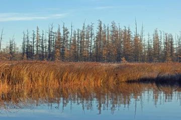
Photo by Thomas A. Meyer/DNR
Hook Lake Bog ranks as one of the highest-quality wetlands in Dane County. It is a soft bog lake, which is unusual for southern Wisconsin. The lake, located in a glacial pocket, is nearly extinct with only 50-70 acres of open water remaining. The rest is covered by a floating sedge mat and emergent aquatic vegetation with tamarack swamp forest, open bog, and southern sedge meadow communities. The bog mat harbors plant species that are rare in Dane County including the insectivorous round-leaved sundew, seven-angled pipewort, and bogbean.
Other Dane County rarities are pickerelweed, water shield, leather-leaf, and large-fruited star sedge. The tamarack swamp contains paper birch, cranberry, and spinulose wood fern and a dense ring of bog birch surrounds the tamaracks with cotton grass. Other species include steeplebush, buttonbush, American woolly-fruit sedge, rushes, and spike-rush. A cat-tail-dominated moat with water plantain, swamp loosestrife, wool grass, and arrowhead surrounds the bog. An upland island of the dry-mesic forest is also present and is rich with spring wildflowers such as Dutchman’s-breeches and bloodroot.
The natural area also contains a restored prairie and oak savanna along the western edge of the lake. The diversity and structure of the vegetation offers a variety of habitats and cover for wildlife, including open water, reed beds, sedge, cat-tails, shrub, and deciduous and coniferous forest areas. Nesting birds include the common snipe, woodcock, sora rail, green heron, wood duck, and pied-billed grebe. Great blue herons also use the area for foraging. Hook Lake Bog is owned by the DNR and was designated a State Natural Area in 1991.
Very few State Natural Areas have public facilities, but nearly all are open for a variety of recreational activities as indicated below. Generally, there are no picnic areas, restrooms, or other developments. Parking lots or designated parking areas are noted on individual SNA pages and maps. If a developed trail is present, it will normally be noted on the SNA map and/or under the Maps tab. A compass, topographic map, or GPS unit are useful tools for exploring larger, isolated SNAs.
The good majority of SNAs are isolated and have few or no facilities. Some SNAs have vehicle access lanes or parking lots, but their accessibility may vary depending on weather conditions. Parking lots and lanes are not plowed during winter. Hiking trails may be nonexistent or consist of undeveloped footpaths. A GPS unit or compass and a detailed topographic map are valuable tools for exploring larger SNAs.
Entrance fees: Except for Parfrey's Glen, the Cambrian Outlook in the Dells of the Wisconsin River, SNAs within State Parks and some within State Forests, all other DNR-owned SNAs do not have any admission fees. For more information, see Wis. Admin. Code NR 45 [exit DNR]. For non-DNR-owned SNAs, we are unaware of any vehicle or admission fees. However, please contact the landowner for more information.
Allowable activities: DNR-owned land
The activities listed below are generally allowed on all DNR-owned SNA lands. Exceptions to this list of public uses, such as SNAs closed to hunting, are noted above and posted with signs on the property site.
- Hiking
- Fishing
- Cross country skiing
- Hunting
- Trapping
- Scientific research (permit required [PDF])
- Outdoor education
- Wild edibles (What is this?)
- Pets (Rules)
- Wildlife viewing
Prohibited activities: all SNAs
Although a handful of sites allow activities like primitive camping (e.g. Lower Chippewa River on sand bars) or horseback riding (e.g. S. Kettle Moraine), the activities listed below are generally prohibited on DNR-owned SNAs.
- Camping and campfires
- Collecting of animals (other than legally harvested species), non-edible fungi, rocks, minerals, fossils, archaeological artifacts, soil, downed wood, or any other natural material, alive or dead.
- Collecting for scientific research requires a permit issued by the DNR
- Collecting of plants including seeds, roots or other non-edible parts of herbaceous plants such as wildflowers or grasses
- Drones: Flying-related activities, including the use of drones, hang-gliders and model airplanes, are prohibited. Permission may be issued by the SNA Program for the use of drones for educational or research purposes
- Geocaching
- Horseback riding
- Rock climbing
- Vehicles, including bicycles, ATVs, aircraft, and snowmobiles except on trails and roadways designated for their use.
For rules governing state-owned SNAs and other state lands, please consult Chapter NR 45 Wis. Admin. Code [exit DNR].
Location
Dane County. T6N-R8E, Section 28, 29, 32. 527 acres.
Driving directions
From the junction of Highways 14 and 138 in Oregon, go east on 138 for 1.8 miles, then north on Sunrise Road for 0.85 miles, then east on Rutland Dunn Town Line Road for 0.3 miles, then north on McManus Road for 0.1 miles to a small parking area. Walk north 1 mile into the site. Though challenging, there is an unmarked walk-in canoe/kayak access to the water. From the intersection of Sunrise and Rutland Dunn Town Line Road (as described above), go west on Rutland Dunn Town Line Road for 0.6 miles and park along the roadside between residences at 4360 and 4382. This is just west of a power line that runs north/south over the road. Carry your boat due north through the old field about 300’ to the bog’s edge. Paddle west to get to open water. This may require pulling your boat over some short patches of bog. Areas of thick water lilies in summer may also make paddling difficult. Look at an air photo of the site before venturing onto the water.
The DNR's state natural areas program is comprised of lands owned by the state, private conservation organizations, municipalities, other governmental agencies, educational institutions and private individuals. While the majority of SNAs are open to the public, access may vary according to individual ownership policies. Public use restrictions may apply due to public safety, or to protect endangered or threatened species or unique natural features. Lands may be temporarily closed due to specific management activities.
Users are encouraged to contact the landowner for more specific details. The data shown on these maps have been obtained from various sources, and are of varying age, reliability, and resolution. The data may contain errors or omissions and should not be interpreted as a legal representation of legal ownership boundaries. To create your custom map where you can zoom to a specific location, please use the DNR's Mapping Application.
Hook Lake Bog is owned by: Wisconsin DNR