Honey Creek
No. 91
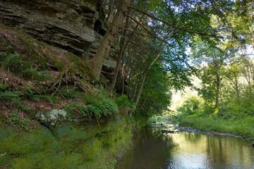
Photo by Thomas A. Meyer/DNR
Honey Creek State Natural Area lies along a portion of Honey Creek, a Class II trout stream that flows to the Wisconsin River. The topography ranges from creek bottoms and boggy areas through steep slopes and rock escarpments to upland ridges. Within the natural area boundaries, there are twenty-five distinct soil types. Given this range in topography and soils, it is no surprise that the site supports varied and unusual flora and fauna. More than five hundred plant species thrive here. The site was originally protected as a bird sanctuary, and more than 80 species have been recorded during the nesting season. Unusual nesting species include veery, blue-gray gnatcatcher, yellow-throated vireo, and blue-winged warbler. Honey Creek is owned by the Wisconsin Society for Ornithology and the Wisconsin Chapter of the Nature Conservancy. It was designated a State Natural Area in 1971.
Very few State Natural Areas have public facilities, but nearly all are open for a variety of recreational activities as indicated below. Generally, there are no picnic areas, restrooms, or other developments. Parking lots or designated parking areas are noted on individual SNA pages and maps. If a developed trail is present, it will usually be noted on the SNA map and/or under the Maps tab. A compass, topographic map, or GPS unit are useful tools for exploring larger, isolated SNAs.
The good majority of SNAs are isolated and have few or no facilities. Some SNAs have vehicle access lanes or parking lots, but their accessibility may vary depending on weather conditions. Parking lots and lanes are not plowed during winter. Hiking trails may be nonexistent or consist of undeveloped footpaths. A GPS unit or compass and a detailed topographic map are valuable tools for exploring larger SNAs.
Non-DNR lands
Entrance fees: For non-DNR-owned SNAs, we are unaware of any vehicle or admission fees. However, please contact the landowner for more information.
Hunting and trapping
This is a non-DNR-owned SNA: Opportunities for hunting and trapping depend on the landowner. Please contact them directly to find out about their rules for hunting and trapping. You can find a link to other owner websites under the Resources tab.
For hunting opportunities on Nature Conservancy land, visit The Nature Conservancy's Deer Management [exit DNR].
Other activities
Other allowable activities such as - but not limited to camping, geocaching and bicycling are determined by the landowner. Please contact them directly or visit their websites for details.
Location
Sauk County. T10N-R4E, Sections 2, 3, 11, 12, 14. T11N-R4E, Section 35. 695 acres.
Driving directions
From the intersection of Highways 12 and PF, just west of Prairie du Sac, go west on County PF 14.3 miles, then west on Skyview Road (Lins Road on older maps) 0.5 miles to the site.
The DNR's state natural areas program is comprised of lands owned by the state, private conservation organizations, municipalities, other governmental agencies, educational institutions, and private individuals. While the majority of SNAs are open to the public, access may vary according to individual ownership policies. Public use restrictions may apply due to public safety, or to protect endangered or threatened species or unique natural features. Lands may be temporarily closed due to specific management activities.
Users are encouraged to contact the landowner for more specific details. The data shown on these maps have been obtained from various sources, and are of varying age, reliability, and resolution. The data may contain errors or omissions and should not be interpreted as a legal representation of legal ownership boundaries. To create your custom map where you can zoom to a specific location, please use the DNR's Mapping Application.
Honey Creek is owned by: The Nature Conservancy and the Wisconsin Society for Ornithology