Holland Sand Prairie
No. 553
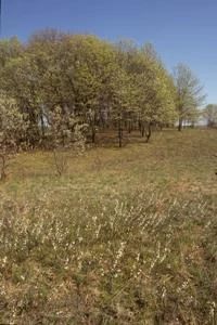
Photo by Thomas A. Meyer/DNR
Situated on an expansive, gently-rolling Mississippi River sand terrace, Holland Sand Prairie protects the last sizable sand prairie remnant remaining between Trempealeau and Prairie du Chien. The prairie is diverse with nearly 150 native plant species identified to date. Large patches of uncommon plants such as prairie smoke, silky prairie clover, and sand dropseed are scattered throughout the site. Other species include little bluestem, side-oats grama, June grass, clasping milkweed, silky aster, prairie coreopsis, rough blazing-star, hairy puccoon, purple prairie clover, and goat's-rue. Of note is the presence of a state-threatened plant.
The landscape also contains large vegetated "dunes" that are an extremely rare geological landform in the area, which were created thousands of years ago by wind-swept sands on the Mississippi River Terrace. The prairie has been heavily studied and used over the years by area students, teachers, and researchers. Very few comparable sites remain on the Wisconsin side of the Mississippi and most occur within railroad rights-of-way. Numerous individuals and groups collaborated to permanently protect this site including the citizens of Holland Township, Mississippi Valley Conservancy, and the Wisconsin DNR. Holland Sand Prairie is owned by Mississippi Valley Conservancy and was designated a State Natural Area in 2007.
Very few State Natural Areas have public facilities, but nearly all are open for a variety of recreational activities as indicated below. Generally, there are no picnic areas, restrooms, or other developments. Parking lots or designated parking areas are noted on individual SNA pages and maps. If a developed trail is present, it will usually be noted on the SNA map and/or under the Maps tab. A compass, topographic map, or GPS unit are useful tools for exploring larger, isolated SNAs.
The good majority of SNAs are isolated and have few or no facilities. Some SNAs have vehicle access lanes or parking lots, but their accessibility may vary depending on weather conditions. Parking lots and lanes are not plowed during winter. Hiking trails may be nonexistent or consist of undeveloped footpaths. A GPS unit or compass and a detailed topographic map are valuable tools for exploring larger SNAs.
Non-DNR lands
Entrance fees: For non-DNR-owned SNAs, we are unaware of any vehicle or admission fees. However, please contact the landowner for more information.
Hunting and trapping
Other activities
Other allowable activities such as - but not limited to camping, geocaching and bicycling are determined by the landowner. Please contact them directly or visit their websites for details.
Location
La Crosse County. T17N-R8W, Section 11. 61 acres.
Driving directions
From the intersection of County DH (Main St) and E McHugh Court (County MH) on the north side of Holmen, go west on County MH 1.5 miles to a parking area south of the road.
The DNR's state natural areas program is comprised of lands owned by the state, private conservation organizations, municipalities, other governmental agencies, educational institutions, and private individuals. While the majority of SNAs are open to the public, access may vary according to individual ownership policies. Public use restrictions may apply due to public safety, or to protect endangered or threatened species or unique natural features. Lands may be temporarily closed due to specific management activities.
Users are encouraged to contact the landowner for more specific details. The data shown on these maps have been obtained from various sources, and are of varying age, reliability, and resolution. The data may contain errors or omissions and should not be interpreted as a legal representation of legal ownership boundaries. To create your custom map where you can zoom to a specific location, please use the DNR's Mapping Application.
Holland Sand Prairie is owned by: Town of Holland