Hemlock Draw
No. 535
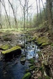
Photo by Thomas A. Meyer/DNR
Situated along Honey Creek, Hemlock Draw is a narrow gorge of sandstone and conglomerate rock that supports species with more northerly affinities. Dense stands of hemlock and yellow birch line the stream and gorge and shelter many northern forest plants such as several club-moss species. Sedges, skunk cabbage, and witch hazel also grow along the flat-bottomed draw. On the flanks of the draw, hemlock and other northern species give way to rich forests of sugar maple, red oak, ironwood, and big-tooth aspen. Wood anemones, wild geranium, and early meadow rue all flower abundantly under the large trees. Drier forests dominated by red oak grow on the bluff tops north and south of the draw.
In all, the site features five major kinds of forest along with several interesting cliff and glade communities. On quartzite, outcroppings are two examples of acid bedrock glades that support populations of two rare plants. More rare plants are found in the southern dry-mesic forest on the south ridge while the draw itself shelters several other rare species. As part of the Baraboo Hills landscape, this site contains important breeding and migratory habitat for many bird species. More than 40 species of breeding birds, including barred owls, ruffed grouse, wood thrush, 6 species of warbler, and 4 species of woodpeckers depend on Hemlock Draw for food and cover. Hemlock Draw is owned by the Wisconsin Chapter of The Nature Conservancy and was designated a State Natural Area in 2007.
Very few State Natural Areas have public facilities, but nearly all are open for a variety of recreational activities as indicated below. Generally, there are no picnic areas, restrooms, or other developments. Parking lots or designated parking areas are noted on individual SNA pages and maps. If a developed trail is present, it will usually be noted on the SNA map and/or under the Maps tab. A compass, topographic map, or GPS unit are useful tools for exploring larger, isolated SNAs.
The good majority of SNAs are isolated and have few or no facilities. Some SNAs have vehicle access lanes or parking lots, but their accessibility may vary depending on weather conditions. Parking lots and lanes are not plowed during winter. Hiking trails may be nonexistent or consist of undeveloped footpaths. A GPS unit or compass and a detailed topographic map are valuable tools for exploring larger SNAs.
Non-DNR lands
Entrance fees: For non-DNR-owned SNAs, we are unaware of any vehicle or admission fees. However, please contact the landowner for more information.
Hunting and trapping
This is a non-DNR-owned SNA: Opportunities for hunting and trapping depend on the landowner. Please contact them directly to find out about their rules for hunting and trapping. You can find a link to other owner websites under the Resources tab.
For hunting opportunities on Nature Conservancy land, visit The Nature Conservancy's Deer Management [exit DNR].
Other activities
Other allowable activities such as - but not limited to camping, geocaching and bicycling are determined by the landowner. Please contact them directly or visit their websites for details.
Location
Sauk County. T10N-R5E, Section 5. 685 acres.
Driving directions
From the intersection of Highway 12 and County PF north of Sauk City, go west on PF 12 miles, then north on County C 0.25 miles into Leland, then north on Hemlock Road for 2 miles, and continue on Reich Drive 0.5 miles to the gate. Park along the shoulder of the road south of the mailbox. Please do not block Reich Drive as local farmers use it to move large equipment. For access from the north (and the dedicated SNA parcel), from the intersection of PF and C in Leland, go north on C for 2 miles, then north on Orchard Road for 2.5 miles, then west on Schara Road for 0.5 miles. Park along the shoulder and walk south into the site.
The DNR's state natural areas program is comprised of lands owned by the state, private conservation organizations, municipalities, other governmental agencies, educational institutions, and private individuals. While the majority of SNAs are open to the public, access may vary according to individual ownership policies. Public use restrictions may apply due to public safety, or to protect endangered or threatened species or unique natural features. Lands may be temporarily closed due to specific management activities.
Users are encouraged to contact the landowner for more specific details. The data shown on these maps have been obtained from various sources, and are of varying age, reliability, and resolution. The data may contain errors or omissions and should not be interpreted as a legal representation of legal ownership boundaries. To create your custom map where you can zoom to a specific location, please use the DNR's Mapping Application.
Hemlock Draw is owned by: The Nature Conservancy