Headwater Lakes
No. 480
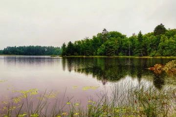
Photo by Aaron Carlson
Headwater Lakes features two unique soft-water lakes, Wabasso Lake and Cedar Lake. Wabasso Lake is a 49-acre deep, seepage lake with diverse and unusual aquatic flora. The submerged aquatic plants are the principal features of interest, with several specialized sterile rosette species well represented. Lakes that support sterile rosette species are deep, land-locked, and have sandy bottoms. The clear, soft water allows for the growth of this unique assemblage of plants. They include water lobelia, pipewort, Spiney-spored quillwort, and waterwort. Associated submerged and floating-leaved aquatics include fragrant water lily, golden-pert, large-leaved pondweed, American eelgrass, and water shield. Emergent aquatics along the shore include swamp loosestrife, pickerel weed, and water arum.
A good population of the carnivorous plant species, purple bladderwort also occurs here. The ericad bog is dominated by labrador tea, leatherleaf, and bog laurel along with scattered tamarack. The understory contains Sphagnum moss and typical bog plants such as pond sedge, swamp false Solomon's seal, and round-leaved sundew. Uplands surrounding the lake contain patches of old-growth hemlock with yellow birch, white pine, red pine, and paper birch. In addition, fair to good quality stands of white cedar swamp and mixed pine forest adjoins the mesic forest. Cedar Lake is an undeveloped, shallow, drainage lake that still retains a wilderness aspect due to its remote location. Most of the lake margin is fringed with cattail marsh and sedge meadow.
Associated wetlands include vast open peatlands dominated by bog ericads, tamarack swamp, and black spruce/tamarack bog. Uplands within the site are forested with fair to good quality stands of the mixed pine forest of natural origin. Also present is a wet-mesic hemlock-dominated forest and a mesic hardwood forest of diverse species composition. Of special interest are several groves of old-growth red and white pines on the west side of Cedar Lake. Headwater Lakes is owned by the U.S. Forest Service and was designated a State Natural Area in 2007. This site is also recognized by the Forest Service as an established Research Natural Area.
Very few State Natural Areas have public facilities, but nearly all are open for a variety of recreational activities as indicated below. Generally, there are no picnic areas, restrooms, or other developments. Parking lots or designated parking areas are noted on individual SNA pages and maps. If a developed trail is present, it will usually be noted on the SNA map and/or under the Maps tab. A compass and topographic map or a GPS unit are useful tools for exploring larger, isolated SNAs.
The good majority of SNAs are isolated and have few or no facilities. Some SNAs have vehicle access lanes or parking lots, but their accessibility may vary depending on weather conditions. Parking lots and lanes are not plowed during winter. Hiking trails may be nonexistent or consist of undeveloped footpaths. A GPS unit or compass and a detailed topographic map are useful tools for exploring larger SNAs.
Non-DNR lands
Entrance fees: For non-DNR-owned SNAs, we are unaware of any vehicle or admission fees. However, please contact the landowner for more information.
Hunting and trapping
Other activities
Other allowable activities such as - but not limited to camping, geocaching and bicycling are determined by the landowner. Please contact them directly or visit their websites for details.
Location
Within the Chequamegon-Nicolet National Forest. Vilas County. T40N-R4E, Sections 4-9, 17, 18, 20. 2,893 acres.
Driving directions
From Minocqua, go west on Highway 70 for 15 miles, then north on FR 509 (Chippewa Trail) to its junction with FR 142. The site lies west and northeast of the intersection.
The DNR's state natural areas program is comprised of lands owned by the state, private conservation organizations, municipalities, other governmental agencies, educational institutions, and private individuals. While the majority of SNAs are open to the public, access may vary according to individual ownership policies. Public use restrictions may apply due to public safety, or to protect endangered or threatened species or unique natural features. Lands may be temporarily closed due to specific management activities.
Users are encouraged to contact the landowner for more specific details. The data shown on these maps have been obtained from various sources, and are of varying age, reliability, and resolution. The data may contain errors or omissions and should not be interpreted as a legal representation of legal ownership boundaries. To create your custom map where you can zoom to a specific location, please use the DNR's Mapping Application.
Headwater Lakes is owned by: U.S. Forest Service