Haymeadow Flowage
No. 482
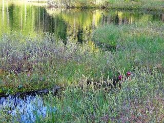
Photo by Aaron Carlson
Haymeadow Flowage features a core of open and wooded wetland communities associated with the Haymeadow Creek and Flowage. Of note are old-growth hemlock-hardwood stands that are rare on this land type on the Nicolet. There is a good representation of the mature and seral-stage forest communities that naturally occur on these rather dry and nutrient-poor habitat types. Wetlands range from open water and areas of cattails and floating sedge hummocks in the flowage proper, to black spruce muskeg-type bogs, mainly to the north of Haymeadow Creek.
Several mixed conifer swamps with significant white-cedar components are scattered throughout the site, though none contain extensive areas of closed-canopy white-cedar. A high-quality open bog with two small bog lakes is located on the north edge of the complex. Several large red pine-dominated islands occur within the wetland matrix. Surrounding uplands are generally rolling pitted sandy outwash with some steep slopes bordering lowlands. A variety of communities occur, from stands of old-growth hemlock-hardwoods to healthy younger mixed forests of red and white pine, red oak, red maple, and paper birch on the dryer, sandier soils.
Most of the better upland stands are north of Haymeadow Creek, often in fairly narrow bands on steep slopes bordering lowlands. Ecological gradients are generally intact. Most upland stands have a mature pine component, often super-canopy white pine, with 26-30 inches in diameter fairly common in a few stands. Hemlock sizes are comparable, with one measured at 40 inches in diameter. The best stands exhibit a pronounced old-growth structure. Haymeadow Flowage is owned by the US Forest Service and was designated a State Natural Area in 2007.
Very few State Natural Areas have public facilities, but nearly all are open for a variety of recreational activities as indicated below. Generally, there are no picnic areas, restrooms, or other developments. Parking lots or designated parking areas are noted on individual SNA pages and maps. If a developed trail is present, it will usually be noted on the SNA map and/or under the Maps tab. A compass and topographic map or a GPS unit are useful tools for exploring larger, isolated SNAs.
The good majority of SNAs are isolated and have few or no facilities. Some SNAs have vehicle access lanes or parking lots, but their accessibility may vary depending on weather conditions. Parking lots and lanes are not plowed during winter. Hiking trails may be nonexistent or consist of undeveloped footpaths. A GPS unit or compass and a detailed topographic map are useful tools for exploring larger SNAs.
Non-DNR lands
Entrance fees: For non-DNR-owned SNAs, we are unaware of any vehicle or admission fees. However, please contact the landowner for more information.
Hunting and trapping
Other activities
Other allowable activities such as - but not limited to camping, geocaching and bicycling are determined by the landowner. Please contact them directly or visit their websites for details.
Location
Within Chequamegon-Nicolet National Forest. Forest County. T39N-R12E Sections 3-10, 17, 18. T40N-R12E, Sections 26, 33, 34, 35. 1,935 acres.
Driving directions
From Eagle River, go east on State Highway 70 for about 8 miles, then south on Military Road for 3.4 miles, then east on Knapp Road for 2.1 miles. Or continue south on Military Road for another 1.6 miles, then south on Old Military Road for 1.8 miles, then east on Hay Meadow Road for 2.6 miles. The site lies east of the road. It is bordered by Sevenmile Lake and FR 2435 on the west; FR 2179 on the north and east. Several old logging roads and recreational trails provide access to various parts of the site.
The DNR's state natural areas program is comprised of lands owned by the state, private conservation organizations, municipalities, other governmental agencies, educational institutions, and private individuals. While the majority of SNAs are open to the public, access may vary according to individual ownership policies. Public use restrictions may apply due to public safety, or to protect endangered or threatened species or unique natural features. Lands may be temporarily closed due to specific management activities.
Users are encouraged to contact the landowner for more specific details. The data shown on these maps have been obtained from various sources, and are of varying age, reliability, and resolution. The data may contain errors or omissions and should not be interpreted as a legal representation of legal ownership boundaries. To create your custom map where you can zoom to a specific location, please use the DNR's Mapping Application.
Haymeadow Flowage is owned by: U.S. Forest Service