Haymeadow Creek
No. 479
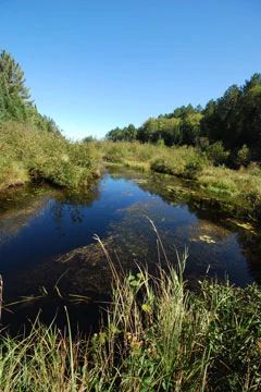
Photo by Josh Mayer
Haymeadow Creek features a large, wet meadow interspersed with elevated islands forested with jack pine, red pine, and white pine. Wet areas contain a thin sphagnum carpet with a ground layer of few-seeded sedge and northern blue-flag iris. The northeastern portion of the site contains a dry mossy opening that supports the uncommon Canada mountain rice grass (Oryzopsis canadensis). Surrounding the meadow is a northern wet forest with a mix of black spruce, tamarack, and northern white cedar. The understory includes species such as bracken fern, Labrador-tea, bunchberry, trailing arbutus, Canada mayflower, wintergreen, and blueberry. The entire complex is an important habitat for several bird species including gray jay, boreal chickadee, Connecticut warbler, Lincoln's sparrow, and yellow-bellied flycatcher. Other species include the yellow-rumped warbler, Nashville warbler, olive-sided flycatcher, Northern parula, white-throated sparrow, and winter wren. Osprey and bald eagle are also known to use the area. Haymeadow Creek is owned by the US Forest Service and was designated a State Natural Area in 2007.
Very few State Natural Areas have public facilities, but nearly all are open for a variety of recreational activities as indicated below. Generally, there are no picnic areas, restrooms, or other developments. Parking lots or designated parking areas are noted on individual SNA pages and maps. If a developed trail is present, it will usually be noted on the SNA map and/or under the Maps tab. A compass and topographic map or a GPS unit are useful tools for exploring larger, isolated SNAs.
The good majority of SNAs are isolated and have few or no facilities. Some SNAs have vehicle access lanes or parking lots, but their accessibility may vary depending on weather conditions. Parking lots and lanes are not plowed during winter. Hiking trails may be nonexistent or consist of undeveloped footpaths. A GPS unit or compass and a detailed topographic map are useful tools for exploring larger SNAs.
Non-DNR lands
Entrance fees: For non-DNR-owned SNAs, we are unaware of any vehicle or admission fees. However, please contact the landowner for more information.
Hunting and trapping
Other activities
Other allowable activities such as - but not limited to camping, geocaching and bicycling are determined by the landowner. Please contact them directly or visit their websites for details.
Location
Within the Chequamegon-Nicolet National Forest. Vilas County. T42N-R11E, Sections 16, 18, 19, 20. 957 acres.
Driving directions
From the intersection of Highway 32 and County B in Land O’Lakes, go south on 32 for 2.25 miles, then east on County E for 2.7 miles, then south on Blong Road for 1.2 miles. The site lies north and southeast of the road.
The DNR's state natural areas program is comprised of lands owned by the state, private conservation organizations, municipalities, other governmental agencies, educational institutions and private individuals. While the majority of SNAs are open to the public, access may vary according to individual ownership policies. Public use restrictions may apply due to public safety, or to protect endangered or threatened species or unique natural features. Lands may be temporarily closed due to specific management activities.
Users are encouraged to contact the landowner for more specific details. The data shown on these maps have been obtained from various sources, and are of varying age, reliability, and resolution. The data may contain errors or omissions and should not be interpreted as a legal representation of legal ownership boundaries. To create your custom map where you can zoom to a specific location, please use the DNR's Mapping Application.
Haymeadow Creek is owned by: U.S. Forest Service