Hagar Mountain
No. 306
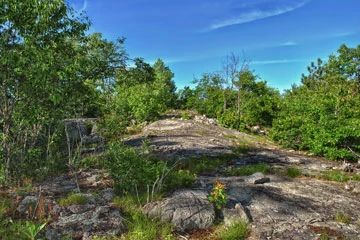
Photo by Aaron Carlson
Hagar Mountain features an excellent example of exposed igneous bedrock habitat with numerous fissures and crevices, which support some unusual plant communities and several rare plants. Also important to this site is one of the northernmost and largest turkey vulture roosting sites in Wisconsin. The steep-sided habitat varies depending on the aspect and condition of the rock. Some south-sloping rock faces and exposed cliffs are virtually bare while north slopes are wooded with hemlock, and north-facing cliffs are often moss and fern-covered. Between these extremes are large areas on the tops of the outcrops that support an interesting lichen and moss flora with occasional colonies of rock spike moss.
Growing in crevices or depressions where the soil has accumulated are common polypody, marginal wood fern, rusty woodsia, pale corydalis, and northern sweet colt's-foot. The site is also sparsely forested with red and Hill's oak, red maple, red, white, and jack pine, and cherry. Rugged talus slopes have formed at the edges of many outcrops and these provide habitat for an additional set of species including rare plants. The natural area itself is quite aesthetic with numerous rock outcrops affording scenic views and having one of the few waterfalls on the Nicolet. Hagar Mountain is owned by the USDA Forest Service and was designated a State Natural Area in 1996.
Very few State Natural Areas have public facilities, but nearly all are open for a variety of recreational activities as indicated below. Generally, there are no picnic areas, restrooms, or other developments. Parking lots or designated parking areas are noted on individual SNA pages and maps. If a developed trail is present, it will usually be noted on the SNA map and/or under the Maps tab. A compass and topographic map or a GPS unit are useful tools for exploring larger, isolated SNAs.
The good majority of SNAs are isolated and have few or no facilities. Some SNAs have vehicle access lanes or parking lots, but their accessibility may vary depending on weather conditions. Parking lots and lanes are not plowed during winter. Hiking trails may be nonexistent or consist of undeveloped footpaths. A GPS unit or compass and a detailed topographic map are useful tools for exploring larger SNAs.
Non-DNR lands
Entrance fees: For non-DNR-owned SNAs, we are unaware of any vehicle or admission fees. However, please contact the landowner for more information.
Hunting and trapping
Other activities
Other allowable activities such as - but not limited to camping, geocaching and bicycling are determined by the landowner. Please contact them directly or visit their websites for details.
Location
Within the Chequamegon-Nicolet National Forest, Oconto County. T31N-R17E, Sections 5, 6, 7. T32N-R17E, Sections 31, 32. 1,006 acres.
Driving directions
From the intersection of State Highway 32 and County Highway W in Mountain, go east on W 3 miles to the junction with FR 2630 (Bear Paw Rd). Continue on W 0.5 mile to a cabin at Fire #13124. Park along W. To reach Hagar Mountain, go north on a foot trail that runs along the property line from the east side of the cabin. Please do not trespass on private land.
The DNR's state natural areas program is comprised of lands owned by the state, private conservation organizations, municipalities, other governmental agencies, educational institutions and private individuals. While the majority of SNAs are open to the public, access may vary according to individual ownership policies. Public use restrictions may apply due to public safety, or to protect endangered or threatened species or unique natural features. Lands may be temporarily closed due to specific management activities.
Users are encouraged to contact the landowner for more specific details. The data shown on these maps have been obtained from various sources, and are of varying age, reliability, and resolution. The data may contain errors or omissions and should not be interpreted as a legal representation of legal ownership boundaries. To create your custom map where you can zoom to a specific location, please use the DNR's Mapping Application.
Hagar Mountain is owned by: U.S. Forest Service