Great River Trail Prairies
No. 357
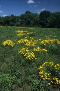
Photo by Thomas A. Meyer/DNR
Great River Trail Prairies features two very diverse sand prairie remnants located on an old railroad right-of-way. Unintentional fires started by the sparks of passing locomotives helped maintain the prairies through time. Today, management such as brushing and prescribed burning helps sustain the prairies. One of the last remnants of the Trempealeau Prairie, they feature grasses such as big and little blue-stem, and flowering plants including lead-plant, blazing-star, wild bergamot, vervain, spiderwort, hoary puccoon, prairie rose white sage. The prairies also harbor a healthy population of rare plants. Great River Trail Prairies is owned by the DNR as part of the Great River State Trail and was designated a State Natural Area in 2002.
Very few State Natural Areas have public facilities, but nearly all are open for a variety of recreational activities as indicated below. Generally, there are no picnic areas, restrooms, or other developments. Parking lots or designated parking areas are noted on individual SNA pages and maps. If a developed trail is present, it will normally be noted on the SNA map and/or under the Maps tab. A compass and topographic map or a GPS unit are useful tools for exploring larger, isolated SNAs.
The good majority of SNAs are isolated and have few or no facilities. Some SNAs have vehicle access lanes or parking lots, but their accessibility may vary depending on weather conditions. Parking lots and lanes are not plowed during winter. Hiking trails may be nonexistent or consist of undeveloped footpaths. A GPS unit or compass and a detailed topographic map are useful tools for exploring larger SNAs.
Entrance fees: Except for Parfrey's Glen, the Cambrian Outlook in the Dells of the Wisconsin River, SNAs within State Parks and some within State Forests, all other DNR-owned SNAs do not have any admission fees. For more information, see Wis. Admin. Code NR 45 [exit DNR]. For non-DNR-owned SNAs, we are unaware of any vehicle or admission fees. However, please contact the landowner for more information.
Allowable activities: DNR-owned land
The activities listed below are generally allowed on all DNR-owned SNA lands. Exceptions to this list of public uses, such as SNAs closed to hunting, are noted above and posted with signs on the property site.
- Hiking
- Fishing
- Cross country skiing
- Hunting
- Trapping
- Scientific research (permit required [PDF])
- Outdoor education
- Wild edibles (What is this?)
- Pets (Rules)
- Wildlife viewing
Prohibited activities: all SNAs
Although a handful of sites allow activities like primitive camping (e.g. Lower Chippewa River on sand bars) or horseback riding (e.g. S. Kettle Moraine), the activities listed below are generally prohibited on DNR-owned SNAs.
- Camping and campfires
- Collecting of animals (other than legally harvested species), non-edible fungi, rocks, minerals, fossils, archaeological artifacts, soil, downed wood, or any other natural material, alive or dead.
- Collecting for scientific research requires a permit issued by the DNR
- Collecting of plants including seeds, roots or other non-edible parts of herbaceous plants such as wildflowers or grasses
- Drones: Flying-related activities, including the use of drones, hang-gliders and model airplanes, are prohibited. Permission may be issued by the SNA Program for the use of drones for educational or research purposes
- Geocaching
- Horseback riding
- Rock climbing
- Vehicles, including bicycles, ATVs, aircraft, and snowmobiles except on trails and roadways designated for their use.
For rules governing state-owned SNAs and other state lands, please consult Chapter NR 45 Wis. Admin. Code [exit DNR].
Location
Along the Great River State Trail, La Crosse and Trempealeau County. T17N-R8W, Sections 14, 15, 16. T18N-R9W, Section 21. 33 acres.
Driving directions
In La Crosse County: From the southernmost intersection of State Highway 35 and County Highway OT in Midway (north of Onalaska), go west on OT 0.6 miles to County Highway ZN, then west on ZN 1.1 miles to County Highway Z, then north on Z 3.5 miles to Lytle Road, then NE on Lytle Road 0.3 mile to its end and the Lytle's Landing Canoe Launch parking area. Walk/ride southeast along the trail into the natural area. The best prairie is located 0.7 miles southeast. In Trempealeau County: From the junction of Third Street (Highway 35) and Main Street in Trempealeau, go north on 35 0.1 miles, then northwest on Park Road 1.4 miles to the intersection of West Prairie Road (just past the cemetery). Park along W. Prairie Road and walk east or west along the recreational trail into the State Natural Area.
The DNR's state natural areas program is comprised of lands owned by the state, private conservation organizations, municipalities, other governmental agencies, educational institutions and private individuals. While the majority of SNAs are open to the public, access may vary according to individual ownership policies. Public use restrictions may apply due to public safety, or to protect endangered or threatened species or unique natural features. Lands may be temporarily closed due to specific management activities.
Users are encouraged to contact the landowner for more specific details. The data shown on these maps have been obtained from various sources, and are of varying age, reliability, and resolution. The data may contain errors or omissions and should not be interpreted as a legal representation of legal ownership boundaries. To create your custom map where you can zoom to a specific location, please use the DNR's Mapping Application.
Great River Trail Prairies is owned by: Wisconsin DNR