Grandma Lake Wetlands
No. 305
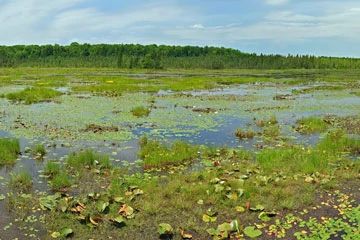
Photo by Aaron Carlson
Grandma Lake Wetlands contains a 44-acre pristine soft water bog lake surrounded by an open mat that supports an unusual and diverse flora. Ringing the lake is a wide, open mat of sphagnum moss, sedge rushes, and low ericaceous shrubs. Locally, the mat composition is quite unusual, with species such as bog club-moss, horned bladderwort, and a bulrush assuming dominance. A conifer swamp of tamarack and black spruce surrounds the open bog. Northern white cedar is also present.
The transition zone between open bog and conifer swamp is occupied by muskeg of widely scattered, stunted swamp conifers within a matrix of typical bog vegetation. Of particular importance is the presence of numerous rare plants, including one that was unknown in the state until 1982. Insectivorous species are quite common including pitcher plant, narrow-leaved sundew, round-leaved sundew, and several bladderworts. Birds include the common loon, merlin, and American bittern. Grandma Lake Wetlands is owned by the U.S. Forest Service and was designated a State Natural Area in 1996. This site is also recognized by the Forest Service as an established Research Natural Area.
Very few State Natural Areas have public facilities, but nearly all are open for a variety of recreational activities as indicated below. Generally, there are no picnic areas, restrooms, or other developments. Parking lots or designated parking areas are noted on individual SNA pages and maps. If a developed trail is present, it will normally be noted on the SNA map and/or under the Maps tab. A compass and topographic map or a GPS unit are useful tools for exploring larger, isolated SNAs.
The good majority of SNAs are isolated and have few or no facilities. Some SNAs have vehicle access lanes or parking lots, but their accessibility may vary depending on weather conditions. Parking lots and lanes are not plowed during winter. Hiking trails may be nonexistent or consist of undeveloped footpaths. A GPS unit or compass and a detailed topographic map are useful tools for exploring larger SNAs.
Non-DNR lands
Entrance fees: For non-DNR-owned SNAs, we are unaware of any vehicle or admission fees. However, please contact the landowner for more information.
Hunting and trapping
Other activities
Other allowable activities such as - but not limited to camping, geocaching and bicycling are determined by the landowner. Please contact them directly or visit their websites for details.
Location
Within Chequamegon-Nicolet National Forest, Florence County. T39N-R15E, Sections 28, 33, 34. 475 acres.
Driving directions
From the intersection of Highway 139 and Elm Street in Long Lake, go south on Highway 139 for 1.9 miles, then east on Tie Mill Road (Forest Road 2402) for 3.4 miles, then south on Forest Road 2158 (Grandma Lake Road) for 0.5 miles to a small pull-off on the west side of the road marked by a brown breeding bird survey fencepost. A footpath leads west 0.2 miles to the bog mat. The most diverse part of the mat lies north and northeast of the lake.
The DNR's state natural areas program is comprised of lands owned by the state, private conservation organizations, municipalities, other governmental agencies, educational institutions and private individuals. While the majority of SNAs are open to the public, access may vary according to individual ownership policies. Public use restrictions may apply due to public safety, or to protect endangered or threatened species or unique natural features. Lands may be temporarily closed due to specific management activities.
Users are encouraged to contact the landowner for more specific details. The data shown on these maps have been obtained from various sources, and are of varying age, reliability, and resolution. The data may contain errors or omissions and should not be interpreted as a legal representation of legal ownership boundaries. To create your custom map where you can zoom to a specific location, please use the DNR's Mapping Application.
Grandma Lake Wetlands is owned by: US Forest Service