Goose Lake
No. 520
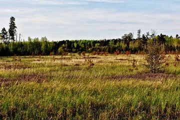
Photo by Aaron Carlson
Goose Lake is an undeveloped 22-acre soft-water seepage lake that supports a high-quality, diverse inland beach community. The lake and wetlands are situated in sandy outwash areas that were once dominated by pine barrens before European settlement. These areas were subjected to regular fires along the lakeshores and sometimes throughout the wetlands creating habitat for sun-loving plants.
The highly fluctuating shoreline prevents the development of a stable shoreline forest or other community and instead supports a specialized flora that is uniquely adapted to the ever-changing conditions. Plants include nodding beggar-ticks, twig-rush, three-way sedge, common spike-rush, common rush, narrow-panicle rush, grass-leaved arrowhead, common three-square bulrush, soft-stem bulrush, northern blue-flag iris, common scouring rush, winter bentgrass, blue-joint grass, and numerous sedges. Nesting waterfowl includes ring-necked duck and blue-winged teal. Goose Lake is owned by Douglas County and was designated a State Natural Area in 2007.
Very few State Natural Areas have public facilities, but nearly all are open for a variety of recreational activities as indicated below. Generally, there are no picnic areas, restrooms, or other developments. Parking lots or designated parking areas are noted on individual SNA pages and maps. If a developed trail is present, it will normally be noted on the SNA map and/or under the Maps tab. A compass and topographic map or a GPS unit are useful tools for exploring larger, isolated SNAs.
The good majority of SNAs are isolated and have few or no facilities. Some SNAs have vehicle access lanes or parking lots, but their accessibility may vary depending on weather conditions. Parking lots and lanes are not plowed during winter. Hiking trails may be nonexistent or consist of undeveloped footpaths. A GPS unit or compass and a detailed topographic map are useful tools for exploring larger SNAs.
Non-DNR lands
Entrance fees: For non-DNR-owned SNAs, we are unaware of any vehicle or admission fees. However, please contact the landowner for more information.
Hunting and trapping
Other activities
Other allowable activities such as - but not limited to camping, geocaching and bicycling are determined by the landowner. Please contact them directly or visit their websites for details.
Location
Within Douglas County Forest, Douglas County. T43N-R10W, Section 10. 67 acres.
Driving directions
From Gordon, go east and south on County G for 7.9 miles, then east and north on Snake Lake Road for 2.8 miles, then east on S. Copper Lake Road for 2.3 miles, then north on Horseshoe Road for 1.4 miles. Park and walk northwest to the site.
The DNR's state natural areas program is comprised of lands owned by the state, private conservation organizations, municipalities, other governmental agencies, educational institutions and private individuals. While the majority of SNAs are open to the public, access may vary according to individual ownership policies. Public use restrictions may apply due to public safety, or to protect endangered or threatened species or unique natural features. Lands may be temporarily closed due to specific management activities.
Users are encouraged to contact the landowner for more specific details. The data shown on these maps have been obtained from various sources, and are of varying age, reliability, and resolution. The data may contain errors or omissions and should not be interpreted as a legal representation of legal ownership boundaries. To create your custom map where you can zoom to a specific location, please use the DNR's Mapping Application.
Goose Lake is owned by: Douglas County