Glocke Lake
No. 304
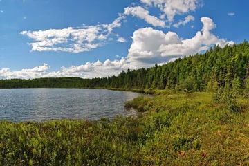
Photo by Aaron Carlson
Glocke Lake is a 28-acre muck-bottomed hard water seepage bog lake with neutral, light brown water and features a large well-developed sphagnum moss, sedge, and ericad mat surrounding the lake. The mat is over 50 feet wide in places and contains several rare plant species. Portions of the mat, which lack the deep sphagnum carpet, support masses of bog club moss, horned bladderwort, narrow-leaved sundew, round-leaved sundew, and pitcher plant. Common ericaceous species include Labrador-tea, bog-laurel, bog-rosemary and cranberries.
The mat is also rich in orchid species. The small-headed bog sedge(Carex tenuiflora) is also found here. Surrounding the lake is a conifer swamp of tamarack and black spruce with scattered red maple, paper birch, white pine, and white cedar. The understory is dense with shrubs on the north end of the lake with speckled alder, mountain holly, and red-osier dogwood. Aquatic plants of the lake community include several pondweeds, yellow pond-lily, water-shield, and seven-angle pipewort. Birds present during the breeding season include common loon, sandhill crane, wood duck, veery, Nashville warbler, and white-throated sparrows. Common mammals using the area include black bears, snowshoe hares, muskrats, and white-tailed deer. Glocke Lake is owned by the U.S.D.A. Forest Service and was designated a State Natural Area in 1996.
Very few State Natural Areas have public facilities, but nearly all are open for a variety of recreational activities as indicated below. Generally, there are no picnic areas, restrooms, or other developments. Parking lots or designated parking areas are noted on individual SNA pages and maps. If a developed trail is present, it will normally be noted on the SNA map and/or under the Maps tab. A compass and topographic map or a GPS unit are useful tools for exploring larger, isolated SNAs.
The good majority of SNAs are isolated and have few or no facilities. Some SNAs have vehicle access lanes or parking lots, but their accessibility may vary depending on weather conditions. Parking lots and lanes are not plowed during winter. Hiking trails may be nonexistent or consist of undeveloped footpaths. A GPS unit or compass and a detailed topographic map are useful tools for exploring larger SNAs.
Non-DNR lands
Entrance fees: For non-DNR-owned SNAs, we are unaware of any vehicle or admission fees. However, please contact the landowner for more information.
Hunting and trapping
Other activities
Other allowable activities such as - but not limited to camping, geocaching and bicycling are determined by the landowner. Please contact them directly or visit their websites for details.
Location
Within the Chequamegon-Nicolet National Forest, Oconto County. T33N-R15E, Sections 13, 14, 24. 162 acres.
Driving directions
From the intersection of State Highway 32 and County Highway T in Townsend, go east on Village View Drive for 0.1 miles, then north on Pickerel Lake Road for 0.9 miles, then east on North Gluckie Lake Trail for 0.6 miles, then southeast on Gluckie Lake Trail (unmarked) about 0.25 mile to an old logging road on the west. Park on the roadside and walk southwest 0.1 miles to the lake.
The DNR's state natural areas program is comprised of lands owned by the state, private conservation organizations, municipalities, other governmental agencies, educational institutions and private individuals. While the majority of SNAs are open to the public, access may vary according to individual ownership policies. Public use restrictions may apply due to public safety, or to protect endangered or threatened species or unique natural features. Lands may be temporarily closed due to specific management activities.
Users are encouraged to contact the landowner for more specific details. The data shown on these maps have been obtained from various sources, and are of varying age, reliability, and resolution. The data may contain errors or omissions and should not be interpreted as a legal representation of legal ownership boundaries. To create your custom map where you can zoom to a specific location, please use the DNR's Mapping Application.
Glocke Lake is owned by: US Forest Service