Ghost Lake
No. 434
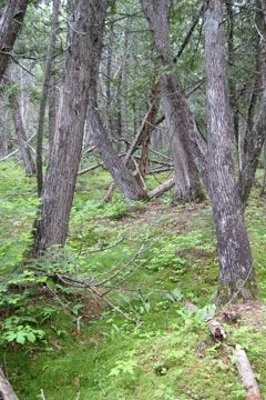
Photo by U.S. Forest Service
Ghost Lake Cedars features a high-quality upland hardwood forest, which still contains significant hemlock and yellow birch component. Also notable are extensive high-quality conifer swamps dominated by medium to large white cedar that contain a diverse and lush ground layer. Bordering Ghost Lake is a mature, wet-mesic forest dominated by medium to large-sized white cedar. Canopy associates include balsam fir, black ash, and paper birch. Most trees are 9-15" in diameter but some are 15"+. Thickets of sapling fir are common.
Cedar saplings are rare and all noted were of sprout origin. Seedlings were locally common on well-rotted moss-covered downed trunks. Blowdowns are frequent. The ground layer is lush and diverse with numerous orchid species present. Spring seeps and muck holes are scattered throughout. Browse damage from white-tailed deer and snowshoe hare is less severe here than in other older cedar stands. The surrounding uplands consist of large, second-growth hemlock hardwoods with hemlock and white pine re-establishing along the lakeshore. Sugar maple is also a dominant canopy species. Ghost Lake is a 372-acre soft-water drainage impoundment on the lower end of Ghost Creek with a maximum depth of 12 feet. Common fish species include muskellunge, largemouth bass, walleye, bluegill, perch, black crappie, pumpkinseeds, and bullheads.
Several migratory and local nesting ducks use the area. Also within the site is Ghost Creek, which originates in Bayfield county and flows south into Ghost Lake and then into the West Fork of the Chippewa River. Other features include a black spruce-tamarack bog with a pine-forested esker, important aquatic resources including undeveloped lake frontage on Ghost Lake dominated by long-lived conifers, free-flowing, medium to large, fast and slow gradient stream segments and associated riparian habitats. Ephemeral ponds and glacial erratics are also present in localized areas. Bird species include a sharp-shinned hawk, hermit thrush, magnolia warbler, Canada warbler, Nashville warbler, northern parula, and rose-breasted grosbeak. Ghost Lake Cedars is owned by the US Forest Service and was designated a State Natural Area in 2007.
Very few State Natural Areas have public facilities, but nearly all are open for a variety of recreational activities as indicated below. Generally, there are no picnic areas, restrooms, or other developments. Parking lots or designated parking areas are noted on individual SNA pages and maps. If a developed trail is present, it will normally be noted on the SNA map and/or under the Maps tab. A compass and topographic map or a GPS unit are useful tools for exploring larger, isolated SNAs.
The good majority of SNAs are isolated and have few or no facilities. Some SNAs have vehicle access lanes or parking lots, but their accessibility may vary depending on weather conditions. Parking lots and lanes are not plowed during winter. Hiking trails may be nonexistent or consist of undeveloped footpaths. A GPS unit or compass and a detailed topographic map are useful tools for exploring larger SNAs.
Non-DNR lands
Entrance fees: For non-DNR-owned SNAs, we are unaware of any vehicle or admission fees. However, please contact the landowner for more information.
Hunting and trapping
Other activities
Other allowable activities such as - but not limited to camping, geocaching and bicycling are determined by the landowner. Please contact them directly or visit their websites for details.
Location
Within the Chequamegon-Nicolet National Forest, Sawyer County. T42N-R5W, Sections 19, 30. T42N-R6W, Sections 25, 31. 394 acres.
Driving directions
From the intersection of Highway 77 and FR 191 in Clam Lake, go south on 77 for about 7 miles, then west of FR 175 to the site.
The DNR's state natural areas program is comprised of lands owned by the state, private conservation organizations, municipalities, other governmental agencies, educational institutions and private individuals. While the majority of SNAs are open to the public, access may vary according to individual ownership policies. Public use restrictions may apply due to public safety, or to protect endangered or threatened species or unique natural features. Lands may be temporarily closed due to specific management activities.
Users are encouraged to contact the landowner for more specific details. The data shown on these maps have been obtained from various sources, and are of varying age, reliability, and resolution. The data may contain errors or omissions and should not be interpreted as a legal representation of legal ownership boundaries. To create your custom map where you can zoom to a specific location, please use the DNR's Mapping Application.
Ghost Lake is owned by: US Forest Service