Germain Hemlocks
No. 355
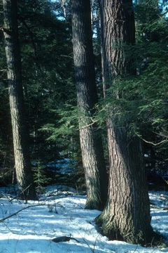
Photo by Thomas A. Meyer/DNR
Situated between three lakes, Germain Hemlocks features steep-sided stony ridges that support an old-growth northern mesic forest dominated by large hemlock with super canopy white and red pines. Canopy associates include yellow birch, sugar maple, red maple, and red oak. The site has numerous large standing snags, pit and mound microtopography, and an abundance of coarse woody debris covering the forest floor. There is strong local reproduction of hemlock. The shrub layer is sparse to moderate and includes beaked hazelnut, American fly honeysuckle, and maple-leaved viburnum. East-facing slopes above Long Lake are covered in some areas by dense hemlock bushes while west-facing slopes above Corner and Tyler Lakes have pockets of small hemlocks 5-10 feet tall.
Large red oak is dominant on south slopes with a well-developed shrub layer present. Along the shore of Corner Lake is a small but good stand of large red pines with an understory of huckleberry and blueberry. Canada mayflower, clubmosses, and intermediate wood fern dominate the understory throughout the area. Other herbaceous species include wild sarsaparilla, rosy twisted-stalk, partridgeberry, wintergreen, large-flowered bellwort, and elliptic shin-leaf. Bird species include common raven, pileated woodpecker, scarlet tanager, red-eyed vireo, ovenbird, and black-and-white, black-throated blue, blackburnian, pine, yellow-rumped, and black-throated green warblers. The natural area is named in honor of Clifford E. Germain, the first ecologist and coordinator of the State Natural Areas Program, who helped protect many such places during his DNR career. Germain Hemlocks is owned by the DNR and was designated a State Natural Area in 2002.
Very few State Natural Areas have public facilities, but nearly all are open for a variety of recreational activities as indicated below. Generally, there are no picnic areas, restrooms, or other developments. Parking lots or designated parking areas are noted on individual SNA pages and maps. If a developed trail is present, it will normally be noted on the SNA map and/or under the Maps tab. A compass and topographic map or a GPS unit are useful tools for exploring larger, isolated SNAs.
The good majority of SNAs are isolated and have few or no facilities. Some SNAs have vehicle access lanes or parking lots, but their accessibility may vary depending on weather conditions. Parking lots and lanes are not plowed during winter. Hiking trails may be nonexistent or consist of undeveloped footpaths. A GPS unit or compass and a detailed topographic map are useful tools for exploring larger SNAs.
Entrance fees: Except for Parfrey's Glen, the Cambrian Outlook in the Dells of the Wisconsin River, SNAs within State Parks and some within State Forests, all other DNR-owned SNAs do not have any admission fees. For more information, see Wis. Admin. Code NR 45 [exit DNR]. For non-DNR-owned SNAs, we are unaware of any vehicle or admission fees. However, please contact the landowner for more information.
Allowable activities: DNR-owned land
The activities listed below are generally allowed on all DNR-owned SNA lands. Exceptions to this list of public uses, such as SNAs closed to hunting, are noted above and posted with signs on the property site.
- Hiking
- Fishing
- Cross country skiing
- Hunting
- Trapping
- Scientific research (permit required [PDF])
- Outdoor education
- Wild edibles (What is this?)
- Pets (Rules)
- Wildlife viewing
Prohibited activities: all SNAs
Although a handful of sites allow activities like primitive camping (e.g. Lower Chippewa River on sand bars) or horseback riding (e.g. S. Kettle Moraine), the activities listed below are generally prohibited on DNR-owned SNAs.
- Camping and campfires
- Collecting of animals (other than legally harvested species), non-edible fungi, rocks, minerals, fossils, archaeological artifacts, soil, downed wood, or any other natural material, alive or dead.
- Collecting for scientific research requires a permit issued by the DNR
- Collecting of plants including seeds, roots or other non-edible parts of herbaceous plants such as wildflowers or grasses
- Drones: Flying-related activities, including the use of drones, hang-gliders and model airplanes, are prohibited. Permission may be issued by the SNA Program for the use of drones for educational or research purposes
- Geocaching
- Horseback riding
- Rock climbing
- Vehicles, including bicycles, ATVs, aircraft, and snowmobiles except on trails and roadways designated for their use.
For rules governing state-owned SNAs and other state lands, please consult Chapter NR 45 Wis. Admin. Code [exit DNR].
Location
Oneida County. T37N-R7E, Section 3 W½SW¼, SW¼NW¼. 88 acres.
Driving directions
From the intersection of U.S. Highway 8 and State Highway 47 on the southwest side of Rhinelander, go north and west on 47 for about 10.3 miles (through McNaughton), then continue west on Fawn Lake Road for about 2.8 miles, then south on South Doe Lane for 0.2 miles to a boat landing on Long Lake. From the landing, walk west (no marked trail) to the top of a north/south ridge to an unmarked logging trail and then walk south along the trail through the natural area. The site is nestled between Long, Corner, and Tyler Lakes.
The DNR's state natural areas program is comprised of lands owned by the state, private conservation organizations, municipalities, other governmental agencies, educational institutions and private individuals. While the majority of SNAs are open to the public, access may vary according to individual ownership policies. Public use restrictions may apply due to public safety, or to protect endangered or threatened species or unique natural features. Lands may be temporarily closed due to specific management activities.
Users are encouraged to contact the landowner for more specific details. The data shown on these maps have been obtained from various sources, and are of varying age, reliability, and resolution. The data may contain errors or omissions and should not be interpreted as a legal representation of legal ownership boundaries. To create your custom map where you can zoom to a specific location, please use the DNR's Mapping Application.
Germain Hemlocks is owned by: Wisconsin DNR