Gasner Hollow Prairie
No. 261
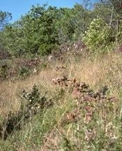
Photo by Eric Epstein
Gasner Hollow Prairie features a steep, dry lime prairie and oak savanna situated on a southwest-facing bluff with exposures of dolomite and sandstone. The savanna is noted for its large component of chinquapin oak, here at the northern limit of its range. Most of the bluff is wooded, with gnarly bur and chinquapin oaks as the canopy dominants. Black and white oak are also present along with a dense shrub layer of hazelnut, gray dogwood, and black raspberry. The limestone rocks and cliffs provide habitat for species such as the smooth cliff brake, walking fern, and slender lip fern that are restricted to calcium-rich substrates. The uppermost slopes and the top narrow ridge support a high-quality dry prairie with a good assemblage of prairie plants, including rare and uncommon ones. Other typical species include pasqueflower, butterfly weed, hoary puccoon, side oats grama grass, needle grass, and little blue-stem. A series of Native American mounds are present on the bluff summit. Gasner Hollow Prairie is owned by private individuals and by the DNR. The site was designated a State Natural Area in 1998.
Very few State Natural Areas have public facilities, but nearly all are open for a variety of recreational activities as indicated below. Generally, there are no picnic areas, restrooms, or other developments. Parking lots or designated parking areas are noted on individual SNA pages and maps. If a developed trail is present, it will normally be noted on the SNA map and/or under the Maps tab. A compass and topographic map or a GPS unit are useful tools for exploring larger, isolated SNAs.
The good majority of SNAs are isolated and have few or no facilities. Some SNAs have vehicle access lanes or parking lots, but their accessibility may vary depending on weather conditions. Parking lots and lanes are not plowed during winter. Hiking trails may be nonexistent or consist of undeveloped footpaths. A GPS unit or compass and a detailed topographic map are useful tools for exploring larger SNAs.
Hunting and trapping
Allowable activities: DNR-owned land
The activities listed below are generally allowed on all DNR-owned SNA lands. Exceptions to this list of public uses, such as SNAs closed to hunting, are noted above and posted with signs on the property site.
- Hiking
- Fishing
- Cross country skiing
- Hunting
- Trapping
- Scientific research (permit required [PDF])
- Outdoor education
- Wild edibles (What is this?)
- Pets (Rules)
- Wildlife viewing
Prohibited activities: all SNAs
- Camping and campfires
- Collecting of animals (other than legally harvested species), non-edible fungi, rocks, minerals, fossils, archaeological artifacts, soil, downed wood, or any other natural material, alive or dead.
- Collecting for scientific research requires a permit issued by the DNR
- Collecting of plants including seeds, roots or other non-edible parts of herbaceous plants such as wildflowers or grasses
- Geocaching
- Horseback riding
- Rock climbing
- Vehicles, including bicycles, ATVs, aircraft, and snowmobiles except on trails and roadways designated for their use.
For rules governing state-owned SNAs and other state lands, please consult Chapter NR 45 Wis. Admin. Code [exit DNR].
Location
Grant County. T5N-R6W, Sections 6, 7, 8. 137 acres.
Driving directions
From the intersection of County Highways X and A in Bagley, go north on X 1.2 miles to Gasner Hollow Road. Park along Gasner Hollow Road and walk upslope (northwest) into the prairie.
The DNR's state natural areas program is comprised of lands owned by the state, private conservation organizations, municipalities, other governmental agencies, educational institutions and private individuals. While the majority of SNAs are open to the public, access may vary according to individual ownership policies. Public use restrictions may apply due to public safety, or to protect endangered or threatened species or unique natural features. Lands may be temporarily closed due to specific management activities.
Users are encouraged to contact the landowner for more specific details. The data shown on these maps have been obtained from various sources, and are of varying age, reliability, and resolution. The data may contain errors or omissions and should not be interpreted as a legal representation of legal ownership boundaries. To create your custom map where you can zoom to a specific location, please use the DNR's Mapping Application.
Gasner Hollow Prairie is owned by: Private and the Wisconsin DNR
Management objectives and prescriptions
Read the Gasner Hollow Prairie management plan [PDF] for details.