Franklin and Butternut Lakes
No. 119
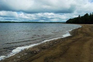
Photo by Josh Mayer
The primary features of Franklin-Butternut Lakes are several small undeveloped lakes and several old-growth hemlock-hardwood stands in a hummocky pitted outwash terrain. The lakes are mostly of the soft water seepage type and range from Sunfish Lake, with its sandy bottom and sterile rosette flora, to a string of bog lakes on the north side of Franklin Lake. Included in the complex is the Bose Lake Hemlock-Hardwoods Research Natural Area, a fine old-growth stand with no evidence of cutting. Mature hemlock, sugar maple, yellow birch, and basswood dominate the forest with paper birch, balsam fir, and red maple among the other trees present. The forest floor has an accumulation of fallen trees, tip-up mounds, and many cradle knolls.
A relatively recent blowdown occurred on the south end of the stand with many large trees on the ground, all of which fell in an ENE direction. The resulting canopy gaps are filled with sugar maple seedlings and saplings. Characteristic ground layer species are intermediate wood fern, wild sarsaparilla, large-leaved aster, Canada mayflower, and club-mosses. Two rare lichens that require old-growth conditions have been found here. Several interconnected stands of hemlock-dominated old growth are on the isthmus between Franklin and Butternut Lakes. The Franklin Nature Trail winds through a portion of them. Smaller stands of old-growth hemlock are found on the east side of Sunfish Lake, on the landward end of the sand spit on the north side of Franklin Lake, and a long esker-like ridge in the vicinity of Two Dutchmen Lake. A few small stands of mature red and white pine occur on the dryer sandy loam soils, while most of the better hardwood and hemlock stands are on silt loams.
The hardwood stands are generally sugar maple-dominated with yellow birch, basswood, and white ash as common associates. Bogs, black spruce-tamarack swamps, and small areas of blue joint grass occupy the lowlands. Ecological gradients, for the most part, are intact. North of Franklin Lake, separated from the main body of the complex, is an area of bogs, bog lakes, and associated conifer swamps set in sandy, cut-over uplands with occasional intact groves of hemlock and red and white pine. Many of the wetland types here are of very good quality. A sand spit anchored by alder and red maple extends far out into Franklin Lake. The lakeshore to the north of the sand spit consists of a long beach ridge and a narrow damp swale supporting mature white pine with royal fern beneath.
The lakeward side of the beach ridge is bordered by alder grading to a large floating sedge mat with a good mix of species. The numerous large old trees and snags situated near lakeshores provide important nesting sites for bald eagles and the lakes see much use by common loons. Other characteristic birds include blackburnian and black-throated green warblers, red-breasted nuthatch, winter wren, and pileated woodpeckers. Originally designated as the 25-acre Bose Lake State Natural Area in 1974, Franklin and Butternut Lakes is owned by the U.S. Forest Service and was expanded in 2007. This site is also recognized by the Forest Service as an established Research Natural Area.
Very few State Natural Areas have public facilities, but nearly all are open for a variety of recreational activities as indicated below. Generally, there are no picnic areas, restrooms, or other developments. Parking lots or designated parking areas are noted on individual SNA pages and maps. If a developed trail is present, it will normally be noted on the SNA map and/or under the Maps tab. A compass and topographic map or a GPS unit are useful tools for exploring larger, isolated SNAs.
The good majority of SNAs are isolated and have few or no facilities. Some SNAs have vehicle access lanes or parking lots, but their accessibility may vary depending on weather conditions. Parking lots and lanes are not plowed during winter. Hiking trails may be nonexistent or consist of undeveloped footpaths. A GPS unit or compass and a detailed topographic map are useful tools for exploring larger SNAs.
Non-DNR lands
Entrance fees: For non-DNR-owned SNAs, we are unaware of any vehicle or admission fees. However, please contact the landowner for more information.
Hunting and trapping
Other activities
Other allowable activities such as - but not limited to camping, geocaching and bicycling are determined by the landowner. Please contact them directly or visit their websites for details.
Location
Within the Chequamegon-Nicolet National Forest, Forest County. T40N-R12E, Sections 15, 16, 17, 20, 21, 23, 26, 27, 28. 1,548 acres.
Driving directions
From the intersection of State Highways 70 and 55 just south of Alvin, go west on 70 for about 7.5 miles, then south on Forest Road 2176 (Divide Road) 2.75 miles to an old logging road (0.1 miles south of lane marked with fire number 15501). Walk west 0.25 miles to the southeast edge of the site. FR 2380, 2181, 2110 and 2140 provide access to various portions of the site.
The DNR's state natural areas program is comprised of lands owned by the state, private conservation organizations, municipalities, other governmental agencies, educational institutions and private individuals. While the majority of SNAs are open to the public, access may vary according to individual ownership policies. Public use restrictions may apply due to public safety, or to protect endangered or threatened species or unique natural features. Lands may be temporarily closed due to specific management activities.
Users are encouraged to contact the landowner for more specific details. The data shown on these maps have been obtained from various sources, and are of varying age, reliability, and resolution. The data may contain errors or omissions and should not be interpreted as a legal representation of legal ownership boundaries. To create your custom map where you can zoom to a specific location, please use the DNR's Mapping Application.
Franklin and Butternut Lakes is owned by: US Forest Service