Fox Maple Woods
No. 282
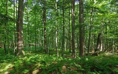
Photo by Thomas A. Meyer/DNR
Fox Maple Woods features an outstanding example of an undisturbed northern mesic forest located within a larger forested landscape and surrounded on three sides by the Whisker Lake Wilderness Area. Canopy dominants include old-growth sugar maple, basswood, hemlock, and yellow birch with white pines sparsely distributed throughout the stand. Scattered white cedar and Canada yew are also present. While the understory is quite open and shows no sign of past disturbance such as grazing, heavy deer browse has been noted.
The shrub layer is minimal but the herbaceous flora is rich and diverse with abundant spring ephemerals such as Carolina spring beauty, yellow dog-tooth violet, Dutchman’s breeches and other herbs including blue cohosh, nodding trillium, rosy twisted-stalk, and bloodroot. A rare sedge also occurs here. A small 5-acre kettle depression in the center of the area supports a sedge meadow and provides an aesthetic opening in the dark mesic woods. Although half of the site has a history of dead timber harvest, the quality of the undisturbed portion is exceptional. This is one of the very few bona fide old-growth mesic forest fragments with a rich ephemeral flora and its protection will help prevent future disturbance. Fox Maple Woods is owned by the DNR and was designated a State Natural Area in 1995.
Very few State Natural Areas have public facilities, but nearly all are open for a variety of recreational activities as indicated below. Generally, there are no picnic areas, restrooms, or other developments. Parking lots or designated parking areas are noted on individual SNA pages and maps. If a developed trail is present, it will normally be noted on the SNA map and/or under the Maps tab. A compass and topographic map or a GPS unit are useful tools for exploring larger, isolated SNAs.
The good majority of SNAs are isolated and have few or no facilities. Some SNAs have vehicle access lanes or parking lots, but their accessibility may vary depending on weather conditions. Parking lots and lanes are not plowed during winter. Hiking trails may be nonexistent or consist of undeveloped footpaths. A GPS unit or compass and a detailed topographic map are useful tools for exploring larger SNAs.
Entrance fees: Except for Parfrey's Glen, the Cambrian Outlook in the Dells of the Wisconsin River, SNAs within State Parks and some within State Forests, all other DNR-owned SNAs do not have any admission fees. For more information, see Wis. Admin. Code NR 45 [exit DNR]. For non-DNR-owned SNAs, we are unaware of any vehicle or admission fees. However, please contact the landowner for more information.
Allowable activities: DNR-owned land
The activities listed below are generally allowed on all DNR-owned SNA lands. Exceptions to this list of public uses, such as SNAs closed to hunting, are noted above and posted with signs on the property site.
- Hiking
- Fishing
- Cross country skiing
- Hunting
- Trapping
- Scientific research (permit required [PDF])
- Outdoor education
- Wild edibles (What is this?)
- Pets (Rules)
- Wildlife viewing
Prohibited activities: all SNAs
Although a handful of sites allow activities like primitive camping (e.g. Lower Chippewa River on sand bars) or horseback riding (e.g. S. Kettle Moraine), the activities listed below are generally prohibited on DNR-owned SNAs.
- Camping and campfires
- Collecting of animals (other than legally harvested species), non-edible fungi, rocks, minerals, fossils, archaeological artifacts, soil, downed wood, or any other natural material, alive or dead.
- Collecting for scientific research requires a permit issued by the DNR
- Collecting of plants including seeds, roots or other non-edible parts of herbaceous plants such as wildflowers or grasses
- Drones: Flying-related activities, including the use of drones, hang-gliders and model airplanes, are prohibited. Permission may be issued by the SNA Program for the use of drones for educational or research purposes
- Geocaching
- Horseback riding
- Rock climbing
- Vehicles, including bicycles, ATVs, aircraft, and snowmobiles except on trails and roadways designated for their use.
For rules governing state-owned SNAs and other state lands, please consult Chapter NR 45 Wis. Admin. Code [exit DNR].
Location
Florence County. T40N-R16E, Section 26 NW¼SW¼. 41 acres.
Driving directions
From the intersection of U.S. Highways 2/141 and State Highway 70 in Florence, go west on Highway 70 10.5 miles to a parking area north of the road. (This is 1.1 miles west of the point where 70 crosses Wakefield Creek).
The DNR's state natural areas program is comprised of lands owned by the state, private conservation organizations, municipalities, other governmental agencies, educational institutions and private individuals. While the majority of SNAs are open to the public, access may vary according to individual ownership policies. Public use restrictions may apply due to public safety, or to protect endangered or threatened species or unique natural features. Lands may be temporarily closed due to specific management activities.
Users are encouraged to contact the landowner for more specific details. The data shown on these maps have been obtained from various sources, and are of varying age, reliability, and resolution. The data may contain errors or omissions and should not be interpreted as a legal representation of legal ownership boundaries. To create your custom map where you can zoom to a specific location, please use the DNR's Mapping Application.
Fox Maple Woods is owned by: Wisconsin DNR