Foulds Creek
No. 435
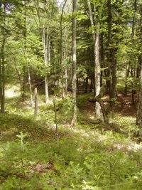
Photo by Linda Parker
Fould's Creek is an aggregation of forested and non-forested stands, which span the continuum of moisture and nutrient gradients from northern mesic forests to wet-mesic to bogs and streams. The primary feature is a large acreage of lowland conifer swamps with numerous good-quality stands of northern white cedar. Hemlock dominates the wet-mesic forest with associated species of white pine, yellow birch, red maple, white cedar, white spruce, and balsam fir. The dominant shrub is American fly honeysuckle. Other shrubs include early low blueberry and mountain maple. American starflower, bunchberry, wood sorrel, Canada mayflower, and wild sarsaparilla dominate the ground layer.
Dominant trees of the northern mesic forest include hemlock, yellow birch, and sugar maple. Associated species include basswood, white pine, and red pine. Associated communities include a black spruce-tamarack bog, alder thicket, hard-water spring runs, and a cold, slow, hard-water stream. Rising above the surrounding till plain and organic peat deposits is a prominent esker running through the site's interior. The esker is oriented in a SE to NW direction, which is unusual in the Chequamegon-Nicolet National Forest.
This "knife-like" ridge is forested with a high-quality example of upland northern mesic forest with hemlock, white cedar, and large-diameter super-canopy red pine, and white pine. Several springs originate at the base of the esker and flow through an adjoining conifer swamp. Small stands of northern hardwoods occur throughout the site. Some areas have a mature stand structure and still retain a residual conifer and yellow birch component. Foulds Creek forms a natural site boundary on the northern and western edges of the site. The interior forest provides important breeding and stopover habitats for many neotropical migrants and other bird species. Foulds Creek is owned by the U.S. Forest Service and was designated a State Natural Area in 2007. This site is also recognized by the Forest Service as an established Research Natural Area.
Very few State Natural Areas have public facilities, but nearly all are open for a variety of recreational activities as indicated below. Generally, there are no picnic areas, restrooms, or other developments. Parking lots or designated parking areas are noted on individual SNA pages and maps. If a developed trail is present, it will normally be noted on the SNA map and/or under the Maps tab. A compass and topographic map or a GPS unit are useful tools for exploring larger, isolated SNAs.
The good majority of SNAs are isolated and have few or no facilities. Some SNAs have vehicle access lanes or parking lots, but their accessibility may vary depending on weather conditions. Parking lots and lanes are not plowed during winter. Hiking trails may be nonexistent or consist of undeveloped footpaths. A GPS unit or compass and a detailed topographic map are useful tools for exploring larger SNAs.
Non-DNR lands
Entrance fees: For non-DNR-owned SNAs, we are unaware of any vehicle or admission fees. However, please contact the landowner for more information.
Hunting and trapping
Other activities
Other allowable activities such as - but not limited to camping, geocaching and bicycling are determined by the landowner. Please contact them directly or visit their websites for details.
Location
Within the Chequamegon-Nicolet National Forest, Price County. T39N-R3E, Sections 13, 22-27. 1,351 acres.
Driving directions
The site can be accessed from Fifield. From the intersection of 70 and 13 in Fifield go east on 70 for 17 miles, then south on Sheep Ranch Road (FR 132) for approximately 2 miles. The site is located on both sides of the road. An esker on the west side of the road provides good upland access to the interior of the site.
The DNR's state natural areas program is comprised of lands owned by the state, private conservation organizations, municipalities, other governmental agencies, educational institutions and private individuals. While the majority of SNAs are open to the public, access may vary according to individual ownership policies. Public use restrictions may apply due to public safety, or to protect endangered or threatened species or unique natural features. Lands may be temporarily closed due to specific management activities.
Users are encouraged to contact the landowner for more specific details. The data shown on these maps have been obtained from various sources, and are of varying age, reliability, and resolution. The data may contain errors or omissions and should not be interpreted as a legal representation of legal ownership boundaries. To create your custom map where you can zoom to a specific location, please use the DNR's Mapping Application.
Foulds Creek is owned by: US Forest Service