Fort McCoy
No. 228
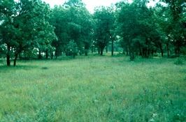
Photo by E. Epstein
Fort McCoy consists of two distinct sites: Silver Creek and Clear Creek. Both creeks are spring-fed, headwater riparian communities in pristine condition. Silver Creek is a fast, cold, hard water stream fed by two major springs that emanate from sandstone caves and seepages along its length. Sedges dominate the open areas along the creek with speckled alder and winterberry. Many rare and unique species are found here, including Cladonia dimorphoclada, a lichen previously unknown in this region. Clear Creek is a soft, alkaline stream with a sandy bottom. The narrow creek is fed by numerous seepages and numerous rare species occur within the area including an extensive population of Massachussets fern (Thelypteris simulata). Fort McCoy SNA previously included a Barrens component. However, this unit was decommissioned in 2020. Fort McCoy is owned by the U.S. Department of Defense and was designated a State Natural Area in 1990.
Very few State Natural Areas have public facilities, but nearly all are open for a variety of recreational activities as indicated below. Generally, there are no picnic areas, restrooms, or other developments. Parking lots or designated parking areas are noted on individual SNA pages and maps. If a developed trail is present, it will normally be noted on the SNA map and/or under the Maps tab. A compass and topographic map or a GPS unit are useful tools for exploring larger, isolated SNAs.
The good majority of SNAs are isolated and have few or no facilities. Some SNAs have vehicle access lanes or parking lots, but their accessibility may vary depending on weather conditions. Parking lots and lanes are not plowed during winter. Hiking trails may be nonexistent or consist of undeveloped footpaths. A GPS unit or compass and a detailed topographic map are useful tools for exploring larger SNAs.
Non-DNR lands
Entrance fees: For non-DNR-owned SNAs, we are unaware of any vehicle or admission fees. However, please contact the landowner for more information.
Hunting and trapping
This is a non-DNR-owned SNA: Opportunities for hunting and trapping depend on the landowner. Please contact them directly to find out about their rules for hunting and trapping. You can find a link to other owner websites under the Resources tab.
A Fort McCoy Access Pass is required for all activities including hunting, fishing, trapping and non-hunting/fishing activities. All recreational users need to update their accounts annually by logging in to their iSportsman account. The Fort McCoy Access Pass is valid from March 1 through February 28 every year. For details, please see the Fort McCoy iSportsman System [exit DNR].
The current Access Pass allows hunters and those scouting the ability to use the Check-in and Check-out system. If you are not able to Check-in, make sure you have the current Access Pass added to your iSportsman account. If having problems, contact the Permit Sales Office at 608-388-3337 for assistance.
A Fort McCoy Access Pass also serves as the permit for Non-hunting/Non-fishing recreational activities such as bird watching, dog walking, berry picking, mushroom hunting, deer antler shed hunting etc.
Non-hunting/Non-fishing activities are not required to Check-in/Check-out but are still required to have the iSportsman Access Pass.
Other activities
Other allowable activities such as - but not limited to camping, geocaching and bicycling are determined by the landowner. Please contact them directly or visit their websites for details.
Location
Within the Fort McCoy Military Installation, Monroe County. T17N-R2E, Sections 16-18. T17N-R3E, Section 13. T19E-R2E, Sections 6-9. 193 acres.
Driving directions
From the intersection of Highways 21 and B in Sparta, go east on 21 8 miles to the Fort McCoy main gate [exit DNR].
The DNR's state natural areas program is comprised of lands owned by the state, private conservation organizations, municipalities, other governmental agencies, educational institutions and private individuals. While the majority of SNAs are open to the public, access may vary according to individual ownership policies. Public use restrictions may apply due to public safety, or to protect endangered or threatened species or unique natural features. Lands may be temporarily closed due to specific management activities.
Users are encouraged to contact the landowner for more specific details. The data shown on these maps have been obtained from various sources, and are of varying age, reliability, and resolution. The data may contain errors or omissions and should not be interpreted as a legal representation of legal ownership boundaries. To create your custom map where you can zoom to a specific location, please use the DNR's Mapping Application.
Fort McCoy is owned by: The US Department of Defense