Five Mile Barrens
No. 318
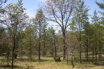
Photo by Andy Clark
The Five Mile Barrens is located in the footprint of the Five Mile Tower Fire, a wildfire that burned in 1977. This fire would eventually burn 13,375 acres of pine forest and was abbe 15 miles long at its longest point. Embers were reported to have flown over a mile ahead of the fire, causing many additional "spot" fires. Five Mile Barrens lies at the midpoint of the fire's path. The site is dominated by jack pine with small inclusions of scrub oak that originated from the fire. The topographic relief is a rolling outwash plain with extensive flat areas. Characteristic barrens plant species present include downy phlox, hoary puccoon, New Jersey tea, rough blazing star, and the state-threatened dwarf milkweed. Five Mile Barrens is owned by Douglas County and was designated a State Natural Area in 2016.
Note: This natural area replaces Buckley Creek Barrens, which was decommissioned.
Very few State Natural Areas have public facilities, but nearly all are open for a variety of recreational activities as indicated below. Generally, there are no picnic areas, restrooms, or other developments. Parking lots or designated parking areas are noted on individual SNA pages and maps. If a developed trail is present, it will normally be noted on the SNA map and/or under the Maps tab. A compass and topographic map or a GPS unit are useful tools for exploring larger, isolated SNAs.
The good majority of SNAs are isolated and have few or no facilities. Some SNAs have vehicle access lanes or parking lots, but their accessibility may vary depending on weather conditions. Parking lots and lanes are not plowed during winter. Hiking trails may be nonexistent or consist of undeveloped footpaths. A GPS unit or compass and a detailed topographic map are useful tools for exploring larger SNAs.
Non-DNR lands
Entrance fees: For non-DNR-owned SNAs, we are unaware of any vehicle or admission fees. However, please contact the landowner for more information.
Hunting and trapping
Other activities
Other allowable activities such as - but not limited to camping, geocaching and bicycling are determined by the landowner. Please contact them directly or visit their websites for details.
Location
Within the Douglas County Forest, Douglas County. T43N-R13W, Sections 28, 33, 34, 35. 1,699 acres.
Driving directions
From the intersection of Highway 53 and County Y in Gordon, go south on Highway 53 for 4.8 miles, then west on County T for 7.8 miles, then south on Kimbal Lake Road for 0.5 miles. The site lies east and west of the road.
The DNR's state natural areas program is comprised of lands owned by the state, private conservation organizations, municipalities, other governmental agencies, educational institutions and private individuals. While the majority of SNAs are open to the public, access may vary according to individual ownership policies. Public use restrictions may apply due to public safety, or to protect endangered or threatened species or unique natural features. Lands may be temporarily closed due to specific management activities.
Users are encouraged to contact the landowner for more specific details. The data shown on these maps have been obtained from various sources, and are of varying age, reliability, and resolution. The data may contain errors or omissions and should not be interpreted as a legal representation of legal ownership boundaries. To create your custom map where you can zoom to a specific location, please use the DNR's Mapping Application.
Five Mile Barrens is owned by: Douglas County