Farmington Bottoms
No. 385
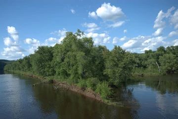
Photo by Josh Mayer
Farmington Bottoms contains excellent examples of floodplain forests, emergent aquatics and forested seeps. Located along a little-developed stretch of the St. Croix, the site features an extensive tract of old-growth lowland forest with running sloughs and backwaters. Silver maple is the dominant canopy species with green ash, hackberry, and American elm. Basswood, red oak, cottonwood, black willow, and yellow bud hickory are also present in smaller numbers. The understory is rather patchy in composition. Some areas are dominated by wood nettle, others by grasses and sedges.
Shallow water areas contain abundant bulrush, rice cut grass and prairie cord grass. Herbaceous plants include cardinal flowers, ostrich fern, ironweed, fringed loosestrife, and false dragonhead. Rough, deeply dissected terrain borders the lower St. Croix River with a local relief exceeding 350 feet. Banks at the base of the river terrace often contain seepages that harbor large populations of rare species of grass. The surrounding upland forest contains oak, basswood, big-tooth aspen, paper birch and an occasional white pine. The shrub layer is generally sparse with American hazelnut and gray dogwood, and there are scattered patches of dry prairie and savanna vegetation on the warmer western and southern exposures. Birds include bald eagle, Louisiana waterthrush, blue-gray gnatcatcher, prothonotary warbler, and numerous rare species. Farmington Bottoms is owned by the National Park Service and was designated a State Natural Area in 2002.
Very few State Natural Areas have public facilities, but nearly all are open for a variety of recreational activities as indicated below. Generally, there are no picnic areas, restrooms, or other developments. Parking lots or designated parking areas are noted on individual SNA pages and maps. If a developed trail is present, it will normally be noted on the SNA map and/or under the Maps tab. A compass and topographic map or a GPS unit are useful tools for exploring larger, isolated SNAs.
The good majority of SNAs are isolated and have few or no facilities. Some SNAs have vehicle access lanes or parking lots, but their accessibility may vary depending on weather conditions. Parking lots and lanes are not plowed during winter. Hiking trails may be nonexistent or consist of undeveloped footpaths. A GPS unit or compass and a detailed topographic map are useful tools for exploring larger SNAs.
Non-DNR lands
Entrance fees: For non-DNR-owned SNAs, we are unaware of any vehicle or admission fees. However, please contact the landowner for more information.
Hunting and trapping
Other activities
Other allowable activities such as - but not limited to camping, geocaching and bicycling are determined by the landowner. Please contact them directly or visit their websites for details.
Location
Within the St. Croix National Scenic Riverway, Polk County. T32N-R19W, Sections 5, 6, 7, 17-20, 29, 30, 32. 1,238 acres.
The DNR's state natural areas program is comprised of lands owned by the state, private conservation organizations, municipalities, other governmental agencies, educational institutions and private individuals. While the majority of SNAs are open to the public, access may vary according to individual ownership policies. Public use restrictions may apply due to public safety, or to protect endangered or threatened species or unique natural features. Lands may be temporarily closed due to specific management activities.
Users are encouraged to contact the landowner for more specific details. The data shown on these maps have been obtained from various sources, and are of varying age, reliability, and resolution. The data may contain errors or omissions and should not be interpreted as a legal representation of legal ownership boundaries. To create your custom map where you can zoom to a specific location, please use the DNR's Mapping Application.
Farmington Bottoms is owned by: National Park Service