Fairyland
No. 474
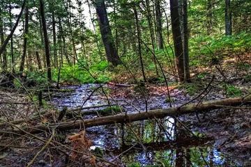
Photo by Aaron Carlson
The core of Fairy Land centers around a relatively undisturbed old-growth hemlock-hardwood forest situated on the shore of Lake Namekagon at the foot of a prominent interlobate moraine. The old-growth stand is embedded in a large block of mature second-growth hardwood forest. Significant inclusions of residual hemlock and yellow birch are present, especially along the shore. Of special interest is the prolific hemlock regeneration with all size classes represented. Associated communities include woodland ephemeral ponds and open bog/sedge meadows.
These stands are bordered to the south by a square mile of old, second-growth mesic to dry-mesic northern hardwood forest. In addition, one-half mile of undeveloped shoreline is represented in the federally designated Research Natural Area. Namekagon Lake is an important waterfowl staging area with large numbers of migratory ducks using the lake in spring and fall. The surrounding wetlands provide nesting habitat for American black ducks, mallards, ring-necked ducks, wood ducks, blue-winged teal, hooded mergansers, and a variety of furbearers. The site also provides excellent potential habitat for common loons, which nest on the lake. A long-time eagle territory is located on nearby Paines Island.
The undeveloped shoreline habitat also provides excellent nursery habitat and adult cover for muskies, northern pike, and largemouth bass. Surveys on Lake Namekagon revealed the highest numbers of spawning muskies were located in this stretch of shoreline. Other significant animals include merlin. Fairyland is owned by the U.S. Forest Service and was designated a State Natural Area in 2007. This site is also recognized by the Forest Service as an established Research Natural Area.
Very few State Natural Areas have public facilities, but nearly all are open for a variety of recreational activities as indicated below. Generally, there are no picnic areas, restrooms, or other developments. Parking lots or designated parking areas are noted on individual SNA pages and maps. If a developed trail is present, it will normally be noted on the SNA map and/or under the Maps tab. A compass and topographic map or a GPS unit are useful tools for exploring larger, isolated SNAs.
The good majority of SNAs are isolated and have few or no facilities. Some SNAs have vehicle access lanes or parking lots, but their accessibility may vary depending on weather conditions. Parking lots and lanes are not plowed during winter. Hiking trails may be nonexistent or consist of undeveloped footpaths. A GPS unit or compass and a detailed topographic map are useful tools for exploring larger SNAs.
Non-DNR lands
Entrance fees: For non-DNR-owned SNAs, we are unaware of any vehicle or admission fees. However, please contact the landowner for more information.
Hunting and trapping
Other activities
Other allowable activities such as - but not limited to camping, geocaching and bicycling are determined by the landowner. Please contact them directly or visit their websites for details.
Location
Within the Chequamegon-Nicolet National Forest. Bayfield County. T43N-R6W, Sections 15, 16, 21. 882 acres.
Driving directions
From the intersection of Highway 63 and Highway M in Cable, go east on M approximately 9 miles to the intersection of FR 203. Public access is only currently allowed on the land located south of Garmisch Road.
The DNR's state natural areas program is comprised of lands owned by the state, private conservation organizations, municipalities, other governmental agencies, educational institutions and private individuals. While the majority of SNAs are open to the public, access may vary according to individual ownership policies. Public use restrictions may apply due to public safety, or to protect endangered or threatened species or unique natural features. Lands may be temporarily closed due to specific management activities.
Users are encouraged to contact the landowner for more specific details. The data shown on these maps have been obtained from various sources, and are of varying age, reliability, and resolution. The data may contain errors or omissions and should not be interpreted as a legal representation of legal ownership boundaries. To create your custom map where you can zoom to a specific location, please use the DNR's Mapping Application.
Fairyland is owned by: US Forest Service