Fairy Chasm
No. 67
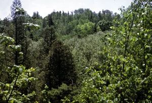
Photo by Wisconsin DNR
Fairy Chasm features an 80-100 foot deep chasm that is cut through unconsolidated till by Fish Creek, a small, fast-flowing, drainage stream. The north-facing aspect, cool air drainage, and cool winds from the lake have created microclimates suitable for many species usually found much farther north. The steep, north-facing slope is forested with white pine, white cedar, paper and yellow birch, sugar maple, beech, and rabbit berry. The gentler, south-facing slope supports a more mesic forest with an abundant juniper ground cover. Several northern plant species are found in the ground layer including leatherwood, beaked hazelnut, several pyrolas, dwarf scouring rush, and sphagnum moss. Soils are sandy clay loams with sand lenses. Fairy Chasm is owned by the Ozaukee Washington Land Trust and was designated a State Natural Area in 1968.
Very few State Natural Areas have public facilities, but nearly all are open for a variety of recreational activities as indicated below. Generally, there are no picnic areas, restrooms, or other developments. Parking lots or designated parking areas are noted on individual SNA pages and maps. If a developed trail is present, it will normally be noted on the SNA map and/or under the Maps tab. A compass and topographic map or a GPS unit are useful tools for exploring larger, isolated SNAs.
The good majority of SNAs are isolated and have few or no facilities. Some SNAs have vehicle access lanes or parking lots, but their accessibility may vary depending on weather conditions. Parking lots and lanes are not plowed during winter. Hiking trails may be nonexistent or consist of undeveloped footpaths. A GPS unit or compass and a detailed topographic map are useful tools for exploring larger SNAs.
Non-DNR lands
Entrance fees: For non-DNR-owned SNAs, we are unaware of any vehicle or admission fees. However, please contact the landowner for more information.
Hunting and trapping
Other activities
Other allowable activities such as - but not limited to camping, geocaching and bicycling are determined by the landowner. Please contact them directly or visit their websites for details.
Location
Ozaukee County. T9N-R22E, Section 33. 22 acres.
Driving directions
Public access to Fairy Chasm is currently NOT available. Please contact the Ozaukee Washington Land Trust [exit DNR] for more information.
The DNR's state natural areas program is comprised of lands owned by the state, private conservation organizations, municipalities, other governmental agencies, educational institutions and private individuals. While the majority of SNAs are open to the public, access may vary according to individual ownership policies. Public use restrictions may apply due to public safety, or to protect endangered or threatened species or unique natural features. Lands may be temporarily closed due to specific management activities.
Users are encouraged to contact the landowner for more specific details. The data shown on these maps have been obtained from various sources, and are of varying age, reliability, and resolution. The data may contain errors or omissions and should not be interpreted as a legal representation of legal ownership boundaries. To create your custom map where you can zoom to a specific location, please use the DNR's Mapping Application.
Fairy Chasm is owned by: Ozaukee Washington Land Trust