Ericson Creek Forest and Wetlands
No. 319
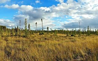
Photo by Aaron Carlson
Ericson Creek and Wetlands harbor a rich combination of natural communities with a diverse composition of species. Ericson Creek forms the western boundary of the natural area before joining the Amnicon River on its journey to Lake Superior. An extensive northern sedge meadow parallels the creek and small pockets of cedar swamp (northern wet-mesic forest) are located along the eastern boundary. The principal feature is the 500-acre open Sphagnum bog and associated muskeg of tamarack and black spruce.
Embedded in the wetland are upland islands containing a boreal forest of white spruce and balsam fir and northern dry-mesic forests dominated by red and white pines. The southern portion of the area contains a northern mesic forest of sugar maple, basswood and red oak. The natural area has had varying degrees of past disturbance, which has increased the amount of site heterogeneity and species diversity. The boreal forest was logged at the turn of the 20th century and has evidence of past fire while the second-growth mesic forest has a history of maple sugaring. The wetlands appear essentially undisturbed. Eighteen rare species have been identified in the natural area, including several birds, butterflies and plants. Ericson Creek and Wetlands is owned by Douglas County and was designated a State Natural Area in 1997.
Very few State Natural Areas have public facilities, but nearly all are open for a variety of recreational activities as indicated below. Generally, there are no picnic areas, restrooms, or other developments. Parking lots or designated parking areas are noted on individual SNA pages and maps. If a developed trail is present, it will normally be noted on the SNA map and/or under the Maps tab. A compass and topographic map or a GPS unit are useful tools for exploring larger, isolated SNAs.
The good majority of SNAs are isolated and have few or no facilities. Some SNAs have vehicle access lanes or parking lots, but their accessibility may vary depending on weather conditions. Parking lots and lanes are not plowed during winter. Hiking trails may be nonexistent or consist of undeveloped footpaths. A GPS unit or compass and a detailed topographic map are useful tools for exploring larger SNAs.
Non-DNR lands
Entrance fees: For non-DNR-owned SNAs, we are unaware of any vehicle or admission fees. However, please contact the landowner for more information.
Hunting and trapping
Other activities
Other allowable activities such as - but not limited to camping, geocaching and bicycling are determined by the landowner. Please contact them directly or visit their websites for details.
Location
Within Douglas County Forest, Douglas County. T45N-R13W, Sections 5, 6. T46N-R13W, Sections 19, 20, 21, 28, 29, 30, 31, 32. 2,505 acres.
Driving directions
From the junction of State Highway 53 and County Highway L, about 6 miles north of Solon Springs, go west on L for about 6.5 miles to South Lyman Lake Rd., then southwest about 1.6 miles to Lucas Rd., then south 0.1 miles to Oliphant Rd., then west about 1 mile to the junction with West Lyman Lake Rd. Park here or farther west along West Lyman Lake Road and walk south into the natural area.
The DNR's state natural areas program is comprised of lands owned by the state, private conservation organizations, municipalities, other governmental agencies, educational institutions and private individuals. While the majority of SNAs are open to the public, access may vary according to individual ownership policies. Public use restrictions may apply due to public safety, or to protect endangered or threatened species or unique natural features. Lands may be temporarily closed due to specific management activities.
Users are encouraged to contact the landowner for more specific details. The data shown on these maps have been obtained from various sources, and are of varying age, reliability, and resolution. The data may contain errors or omissions and should not be interpreted as a legal representation of legal ownership boundaries. To create your custom map where you can zoom to a specific location, please use the DNR's Mapping Application.
Ericson Creek Forest and Wetlands is owned by: Douglas County