Enterprise Hemlocks
No. 608
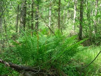
Photo by Wisconsin DNR
Enterprise Hemlocks features stands of mature mesic forest heavily dominated by hemlock with some very old trees present. In the mid-1980s, road crews cut 13 hemlocks for a road improvement project. Upon inspection, a DNR wildlife biologist concluded that four trees were over 200 years in age. One tree had a year of origin of 1720 leading to the conclusion that this area may have escaped harvest during the logging era. Small boggy conifer swamps and ephemeral ponds are scattered throughout the site in kettle depressions.
Larger wetland areas are dominated by extensive acreage of black spruce muskeg and white cedar swamp. Rare plants include the showy lady's-slipper orchid and the small yellow lady's-slipper orchid. The surrounding county forestlands also contain good examples of these community types, including northern hardwoods. This site affords a rare opportunity, in cooperation with Oneida County, to maintain extensive, intact examples of representative northern Wisconsin communities and their associated biota on a landscape scale. Enterprise Hemlocks is owned by the DNR and was designated a State Natural Area in 2010.
Very few State Natural Areas have public facilities, but nearly all are open for a variety of recreational activities as indicated below. Generally, there are no picnic areas, restrooms, or other developments. Parking lots or designated parking areas are noted on individual SNA pages and maps. If a developed trail is present, it will normally be noted on the SNA map and/or under the Maps tab. A compass and topographic map or a GPS unit are useful tools for exploring larger, isolated SNAs.
The good majority of SNAs are isolated and have few or no facilities. Some SNAs have vehicle access lanes or parking lots, but their accessibility may vary depending on weather conditions. Parking lots and lanes are not plowed during winter. Hiking trails may be nonexistent or consist of undeveloped footpaths. A GPS unit or compass and a detailed topographic map are useful tools for exploring larger SNAs.
Hunting and trapping
Allowable activities: DNR-owned land
The activities listed below are generally allowed on all DNR-owned SNA lands. Exceptions to this list of public uses, such as SNAs closed to hunting, are noted above and posted with signs on the property site.
- Hiking
- Fishing
- Cross country skiing
- Hunting
- Trapping
- Scientific research (permit required [PDF])
- Outdoor education
- Wild edibles (What is this?)
- Pets (Rules)
- Wildlife viewing
Prohibited activities: all SNAs
- Camping and campfires
- Collecting of animals (other than legally harvested species), non-edible fungi, rocks, minerals, fossils, archaeological artifacts, soil, downed wood, or any other natural material, alive or dead.
- Collecting for scientific research requires a permit issued by the DNR
- Collecting of plants including seeds, roots or other non-edible parts of herbaceous plants such as wildflowers or grasses
- Geocaching
- Horseback riding
- Rock climbing
- Vehicles, including bicycles, ATVs, aircraft, and snowmobiles except on trails and roadways designated for their use.
For rules governing state-owned SNAs and other state lands, please consult Chapter NR 45 Wis. Admin. Code [exit DNR].
Location
Oneida County. T35N-R9E, Sections 1, 11, 12, 14, 15. 601 acres.
Driving directions
Access is across Oneida County lands. The best forest is found on the two easternmost 80-acre tracts. To reach the northern 80: from the junction of U.S. Highway 8 and County G in Rhinelander, go south on G 8.3 miles to a parking area at the intersection of North (Sugarbush) Road. Walk 0.2 miles north to the southern boundary of the tract. For the southern 80: from the parking area, follow the snowmobile trail (Route 15) west 0.3 miles, then south about 0.6 miles to the tract.
The DNR's state natural areas program comprises lands owned by the state, private conservation organizations, municipalities, other governmental agencies, educational institutions and private individuals. While the majority of SNAs are open to the public, access may vary according to individual ownership policies. Public use restrictions may apply due to public safety, or to protect endangered or threatened species or unique natural features. Lands may be temporarily closed due to specific management activities.
Users are encouraged to contact the landowner for more specific details. The data shown on these maps have been obtained from various sources, and are of varying age, reliability, and resolution. The data may contain errors or omissions and should not be interpreted as a legal representation of legal ownership boundaries. To create your custom map where you can zoom to a specific location, please use the DNR's Mapping Application.
Enterprise Hemlocks is owned by: The Board of Commissioners and the Wisconsin DNR