English Lake Hemlocks
No. 423
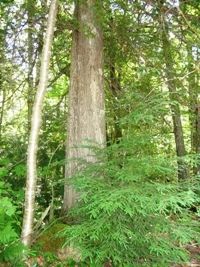
Photo by U.S. Forest Service
English Lake Hemlocks contains an excellent example of upland and swamp hemlock and white cedar forest with an intact gradient from upland to lowland. Most dramatic is the reproduction of both species with all age classes present. The average diameter for dominant hemlock is 14-18 inches with trees greater than 24 inches common. The core of the site is a northern mesic and wet-mesic forest dominated by an overstory of large-diameter hemlock, white cedar, yellow birch, a few scattered white pines, red maple and sugar maple.
The understory is relatively open with young hemlock and cedar, Canada yew, and mountain maple. Ground flora species include wood ferns, American starflower, bunchberry, wood sorrel, and other TMC species. Along the shore of English Lake is a stand with old-growth features, which is bordered by a conifer swamp to the south. Other notable features include shaded rock outcrops; Canada yew; large-diameter red maple and sugar maple, and yellow birch. English Lake itself has excellent aquatic plant life including several large bulrushes (Scirpus) beds adjacent to the site.
English Lake is a soft-water drainage lake. Common fish species include muskellunge, largemouth bass, bluegill, black crappie, perch, and pumpkinseed. Breeding birds include yellow-bellied flycatcher, winter wren, hermit thrush, veery, Nashville warbler, ovenbird, and northern waterthrush. English Lake Hemlocks is owned by the US Forest Service and was designated a State Natural Area in 2007.
Very few State Natural Areas have public facilities, but nearly all are open for a variety of recreational activities as indicated below. Generally, there are no picnic areas, restrooms, or other developments. Parking lots or designated parking areas are noted on individual SNA pages and maps. If a developed trail is present, it will normally be noted on the SNA map and/or under the Maps tab. A compass and topographic map or a GPS unit are useful tools for exploring larger, isolated SNAs.
The good majority of SNAs are isolated and have few or no facilities. Some SNAs have vehicle access lanes or parking lots, but their accessibility may vary depending on weather conditions. Parking lots and lanes are not plowed during winter. Hiking trails may be nonexistent or consist of undeveloped footpaths. A GPS unit or compass and a detailed topographic map are useful tools for exploring larger SNAs.
Non-DNR lands
Entrance fees: For non-DNR-owned SNAs, we are unaware of any vehicle or admission fees. However, please contact the landowner for more information.
Hunting and trapping
Other activities
Other allowable activities such as - but not limited to camping, geocaching and bicycling are determined by the landowner. Please contact them directly or visit their websites for details.
Location
Within the Chequamegon-Nicolet National Forest, Ashland County. T44N-R3W, Sections 8, 9. 155 acres.
Driving directions
The site is located 5 miles west of Mellen, WI. Access is via County Highway GG west 4 miles to Forest Road 1382 (Best Road). Then, turn right on FR 1382, and left after 0.3 miles on a private home access road for 0.5 miles to the site.
The DNR's state natural areas program comprises lands owned by the state, private conservation organizations, municipalities, other governmental agencies, educational institutions and private individuals. While the majority of SNAs are open to the public, access may vary according to individual ownership policies. Public use restrictions may apply due to public safety, or to protect endangered or threatened species or unique natural features. Lands may be temporarily closed due to specific management activities.
Users are encouraged to contact the landowner for more specific details. The data shown on these maps have been obtained from various sources, and are of varying age, reliability, and resolution. The data may contain errors or omissions and should not be interpreted as a legal representation of legal ownership boundaries. To create your custom map where you can zoom to a specific location, please use the DNR's Mapping Application.
English Lake Hemlocks is owned by: US Forest Service