Empire Swamp
No. 517
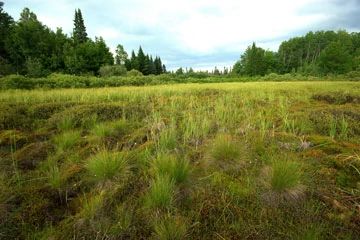
Photo by Josh Mayer
Empire Swamp is a vast peatland complex that serves as the headwaters of the Tamarack River. This extensive site supports a diversity of natural communities including northern sedge meadow, northern wet forest, tamarack swamp, black ash swamp, alder thicket, open bog, and muskeg. Characteristic plants include black chokeberry, bunchberry, huckleberry, blue-joint grass, fowl manna grass, marsh marigold, spring-cress, three-leaved goldthread, sensitive fern, royal fern, gay-wings, American starflower, marsh blue violet.
This large wetland supports a great number of rare plant and animal species including 11 birds, 5 butterflies, and 9 plants. Bird diversity is exceptional with 19 species of warbler present including the highest known density of a state-listed species. In addition, territorial Philadelphia vireo males have been recorded here, which may allow for future confirmation of the first documented breeding in Wisconsin. Other birds include merlin, American bittern, black-billed cuckoo, yellow-bellied sapsucker, yellow-bellied flycatcher, northern raven, golden-crowned kinglet, veery, hermit thrush, Nashville warbler, black and white warbler, northern waterthrush, Canada warbler, and Lincoln's sparrow. Empire Swamp is owned by Douglas County and was designated a State Natural Area in 2007.
Very few State Natural Areas have public facilities, but nearly all are open for a variety of recreational activities as indicated below. Generally, there are no picnic areas, restrooms, or other developments. Parking lots or designated parking areas are noted on individual SNA pages and maps. If a developed trail is present, it will normally be noted on the SNA map and/or under the Maps tab. A compass and topographic map or a GPS unit are useful tools for exploring larger, isolated SNAs.
The good majority of SNAs are isolated and have few or no facilities. Some SNAs have vehicle access lanes or parking lots, but their accessibility may vary depending on weather conditions. Parking lots and lanes are not plowed during winter. Hiking trails may be nonexistent or consist of undeveloped footpaths. A GPS unit or compass and a detailed topographic map are useful tools for exploring larger SNAs.
Non-DNR lands
Entrance fees: For non-DNR-owned SNAs, we are unaware of any vehicle or admission fees. However, please contact the landowner for more information.
Hunting and trapping
Other activities
Other allowable activities such as - but not limited to camping, geocaching and bicycling are determined by the landowner. Please contact them directly or visit their websites for details.
Location
Within the Douglas County Forest. T44N-R13W, Section 6. T44N-R14W, Sections 1, 2, 3, 11, 12. T45N-R13W, Section 31. T45N-R14W, Sections 35, 36. 1,570 acres.
Driving directions
From the intersection of State Highway 35 and County Trunk M in Moose Junction, go east on M for 2.1 miles, then north on Empire Wilderness Road for 4.4 miles. Park and walk east or west into the site.
The DNR's state natural areas program is comprised of lands owned by the state, private conservation organizations, municipalities, other governmental agencies, educational institutions and private individuals. While the majority of SNAs are open to the public, access may vary according to individual ownership policies. Public use restrictions may apply due to public safety, or to protect endangered or threatened species or unique natural features. Lands may be temporarily closed due to specific management activities.
Users are encouraged to contact the landowner for more specific details. The data shown on these maps have been obtained from various sources, and are of varying age, reliability, and resolution. The data may contain errors or omissions and should not be interpreted as a legal representation of legal ownership boundaries. To create your custom map where you can zoom to a specific location, please use the DNR's Mapping Application.
Empire Swamp is owned by: Douglas County