Empire Prairies
No. 146
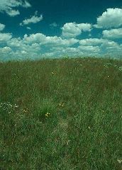
Photo by Thomas A. Meyer/DNR
Empire Prairies contains five prairie remnants and a small oak opening that were once part of the extensive Empire Prairie stretching across southern Columbia and northern Dane counties. Oriented on a northeast to southwest-oriented glacially sculpted ridge is Westport Drumlin Prairie -- a small but diverse prairie containing more than 100 native plant species. A small area of the oak opening, with open-grown bur oaks, occupies the western point of the ridge.
Although the drumlin wears a thin mantle of glacial till, as evidenced by rounded boulders scattered about, limestone bedrock fragments and small outcrops at the drumlin's summit attest to the limited terra-forming action of glacial ice on this ridge. Several showy plant species are present including pasque flower, cream wild indigo, rough blazing star, yellow coneflower, shooting star, bird's-foot violet, compass plant, rosinweed, goldenrods, and asters. Dominant grasses are big and little blue-stem, Indian grass, side oats grama, needle grass, and prairie drop-seed. Located in the Mud Lake Wildlife Area, the Hagen Prairie Unit supports a diversity of plants and features an outstanding display of shooting stars.
While most plants are typical dry-mesic species, wet-mesic species are also present including swamp milkweed and prairie blazing star. Also on the wildlife area is the Mud Lake Prairie Unit, a mesic prairie that will be managed as an ecological reference site. The Ashton Unit is located on an isolated hill surrounded by cropland. The hill is dolomite bedrock with a glacial till near its base. This dry-mesic remnant contains more than 60 native species and is dominated by prairie drop-seed. The Hauser Road unit is owned and managed by The Prairie Enthusiasts. Over 100 native plant species are still present here along with prairie insects and grassland birds. Empire Prairies is owned by the DNR, The Prairie Enthusiasts and private landowners. It was designated a State Natural Area in 1984.
Very few State Natural Areas have public facilities, but nearly all are open for a variety of recreational activities as indicated below. Generally, there are no picnic areas, restrooms, or other developments. Parking lots or designated parking areas are noted on individual SNA pages and maps. If a developed trail is present, it will normally be noted on the SNA map and/or under the Maps tab. A compass and topographic map or a GPS unit are useful tools for exploring larger, isolated SNAs.
The good majority of SNAs are isolated and have few or no facilities. Some SNAs have vehicle access lanes or parking lots, but their accessibility may vary depending on weather conditions. Parking lots and lanes are not plowed during winter. Hiking trails may be nonexistent or consist of undeveloped footpaths. A GPS unit or compass and a detailed topographic map are useful tools for exploring larger SNAs.
Hunting and trapping
Allowable activities: DNR-owned land
The activities listed below are generally allowed on all DNR-owned SNA lands. Exceptions to this list of public uses, such as SNAs closed to hunting, are noted above and posted with signs on the property site.
- Hiking
- Fishing
- Cross country skiing
- Hunting
- Trapping
- Scientific research (permit required [PDF])
- Outdoor education
- Wild edibles (What is this?)
- Pets (Rules)
- Wildlife viewing
Prohibited activities: all SNAs
- Camping and campfires
- Collecting of animals (other than legally harvested species), non-edible fungi, rocks, minerals, fossils, archaeological artifacts, soil, downed wood, or any other natural material, alive or dead.
- Collecting for scientific research requires a permit issued by the DNR
- Collecting of plants including seeds, roots or other non-edible parts of herbaceous plants such as wildflowers or grasses
- Geocaching
- Horseback riding
- Rock climbing
- Vehicles, including bicycles, ATVs, aircraft, and snowmobiles except on trails and roadways designated for their use.
For rules governing state-owned SNAs and other state lands, please consult Chapter NR 45 Wis. Admin. Code [exit DNR].
Location
Dane and Columbia Counties. T8N-R9E, Section 11. T8N-R8E, Section 27. T9N-R9E, Sections 28, 19. T11N-R10E, Sections 24, 28. 202 acres.
Driving directions
For the Westport Drumlin Prairie Unit: From the intersection of Highway 113 and County M, just north of Lake Mendota, go north on 113 for 1.7 miles, then east on Bong Road for 0.8 miles to a parking lot on the north side of the road. For the Hagen Prairie Unit: From the intersection of State Highway 16 and County Trunk C in Rio, go south on C for 2 miles, then west on Hanson Road for 1 mile, then south on Hagen Road for 0.18 miles. Park along the road and walk east on an old farm lane into the natural area. For the Mud Lake Unit: From the intersection of State Highway 51 and County CS Poynette, go east on County CS 3.7 miles, then south on Highway 22 0.7 miles, then east on King Road 0.6 miles to a DNR parking area north of the road. The site lies south of the road in the southeast corner of the property. For the Hauser Road Unit: From the intersection of State Highways 113 and 19, go north on 113, for 2.5 miles, then east and north on Madigan Road for 0.9 miles, then east for 0.4 miles on Hauser Road. The prairie lies south of the road. There is no legal public access to the Ashton Unit at this time.
The DNR's state natural areas program is comprised of lands owned by the state, private conservation organizations, municipalities, other governmental agencies, educational institutions and private individuals. While the majority of SNAs are open to the public, access may vary according to individual ownership policies. Public use restrictions may apply due to public safety, or to protect endangered or threatened species or unique natural features. Lands may be temporarily closed due to specific management activities.
Users are encouraged to contact the landowner for more specific details. The data shown on these maps have been obtained from various sources, and are of varying age, reliability, and resolution. The data may contain errors or omissions and should not be interpreted as a legal representation of legal ownership boundaries. To create your custom map where you can zoom to a specific location, please use the DNR's Mapping Application.
Empire Prairies is owned by: Private and the Wisconsin DNR