Elk River Valley
No. 460
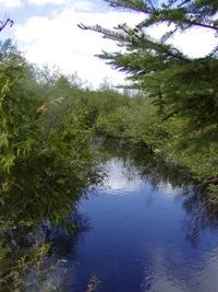
Photo by L. Parker
Elk River Valley contains a diversity of communities including northern wet-mesic forest, hardwood swamp, spring pond, and spring runs. Of notable interest is the high-quality northern wet-mesic forest dominated by older northern white cedar with super canopy white spruce and associated species including balsam fir, yellow birch, and black spruce. The forest is predominantly a closed canopy with small wind-throw gaps with good structure and composition, numerous snags, and coarse woody debris.
Two rare species, Canada yew and northern black currant are found here. Understory plants include speckled alder, American mountain ash, mountain holly, and blueberry ground layer contains at least 7 species of orchid including moccasin-flower, blunt-leaved orchid, early coralroot, and spotted coralroot. Cinnamon fern is common throughout. Other herbaceous species include drooping woodland sedge, swollen sedge, and two-seeded sedge, marsh fern, sensitive fern, shining club-moss, three-leaved gold-thread, swamp saxifrage, small bishop's-cap, wild sarsaparilla, Canada mayflower, and American starflower. Black ash and red maple dominate the northern hardwood swamp. Included in this site is a stretch of the Elk River and associated wetlands. Northern sedge meadows dominated by blue-joint grass and tussock sedge, alder thicket, and shrub carr are found along the river.
The Elk River is a large drainage river that empties into the Flambeau River South Fork. Numerous feeder creeks and streams add to its flow. It has a warm water fishery that includes muskie, northern pike, walleye, both large and small-mouth bass, and panfish. Breeding birds include olive-sided flycatcher, least flycatcher, black-and-white warbler, black-throated green warbler, blackburnian warbler, northern parula, Nashville warbler, and ovenbird. Elk River Valley is owned by the US Forest Service and was designated a State Natural Area in 2007.
Very few State Natural Areas have public facilities, but nearly all are open for a variety of recreational activities as indicated below. Generally, there are no picnic areas, restrooms, or other developments. Parking lots or designated parking areas are noted on individual SNA pages and maps. If a developed trail is present, it will normally be noted on the SNA map and/or under the Maps tab. A compass and topographic map or a GPS unit are useful tools for exploring larger, isolated SNAs.
The good majority of SNAs are isolated and have few or no facilities. Some SNAs have vehicle access lanes or parking lots, but their accessibility may vary depending on weather conditions. Parking lots and lanes are not plowed during winter. Hiking trails may be nonexistent or consist of undeveloped footpaths. A GPS unit or compass and a detailed topographic map are useful tools for exploring larger SNAs.
Non-DNR lands
Entrance fees: For non-DNR-owned SNAs, we are unaware of any vehicle or admission fees. However, please contact the landowner for more information.
Hunting and trapping
Other activities
Other allowable activities such as - but not limited to camping, geocaching and bicycling are determined by the landowner. Please contact them directly or visit their websites for details.
Location
Within the Chequamegon-Nicolet National Forest. Price County. T37N- R3E Sections 5, 8. T38N-R3E, Sections 17, 18, 19, 20, 29-32. 1,444 acres.
Driving directions
The site is located approximately 13 miles east of Phillips and 14 miles southeast of Fifield, Wisconsin. From the intersection of Highway 13 and H in Phillips, go east on Highway H for 9 miles, then east on FR 131 for 4 miles to the Elk River Bridge.
The DNR's state natural areas program comprises lands owned by the state, private conservation organizations, municipalities, other governmental agencies, educational institutions and private individuals. While the majority of SNAs are open to the public, access may vary according to individual ownership policies. Public use restrictions may apply due to public safety, or to protect endangered or threatened species or unique natural features. Lands may be temporarily closed due to specific management activities.
Users are encouraged to contact the landowner for more specific details. The data shown on these maps have been obtained from various sources, and are of varying age, reliability, and resolution. The data may contain errors or omissions and should not be interpreted as a legal representation of legal ownership boundaries. To create your custom map where you can zoom to a specific location, please use the DNR's Mapping Application.
Elk River Valley is owned by: US Forest Service