Ekdall Wetlands
No. 150
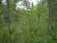
Photo by B. Delaney
Ekdall Wetlands lies on a low terrace, 0.25 to 0.75 miles wide, where the St. Croix River has meandered away from the steep escarpment. The site contains a northern wet forest and alder thicket plus a southern wet-mesic forest, here at its northern range limit in Wisconsin. Flat uplands above the escarpment are about 80 feet above the swamp and consist of barren openings and dense stands of young oaks and jack pine. The escarpment slope also exhibits a continuum from xeric oaks at the summit to more mesic species midslope to swamp species at the wet base.
Numerous seeps near the base contribute water to an open swamp of white cedar, tamarack, black spruce, black ash, and alder with scattered balsam fir and yellow birch. Typical understory species are sphagnum moss, Labrador-tea, pitcher plant, cat-tail, and sedges. Closer to the river are shrub-dominated thickets and small marshy pockets. The soils include wet alluvial land near the river, Cathro muck in the swamp, and sandy soils on the terrace escarpment. Deer use in the area is heavy. Other disturbance includes a ground fire that burned 75 percent of the understory in 1980 and some windthrow in 1977. Ekdall Wetlands is owned by the DNR and National Park Service. It was designated a State Natural Area in 1979 and later expanded to include the St. Croix River.
Very few State Natural Areas have public facilities, but nearly all are open for a variety of recreational activities as indicated below. Generally, there are no picnic areas, restrooms, or other developments. Parking lots or designated parking areas are noted on individual SNA pages and maps. If a developed trail is present, it will normally be noted on the SNA map and/or under the Maps tab. A compass and topographic map or a GPS unit are useful tools for exploring larger, isolated SNAs.
The good majority of SNAs are isolated and have few or no facilities. Some SNAs have vehicle access lanes or parking lots, but their accessibility may vary depending on weather conditions. Parking lots and lanes are not plowed during winter. Hiking trails may be nonexistent or consist of undeveloped footpaths. A GPS unit or compass and a detailed topographic map are useful tools for exploring larger SNAs.
Hunting and trapping
Allowable activities: DNR-owned land
The activities listed below are generally allowed on all DNR-owned SNA lands. Exceptions to this list of public uses, such as SNAs closed to hunting, are noted above and posted with signs on the property site.
- Hiking
- Fishing
- Cross country skiing
- Hunting
- Trapping
- Scientific research (permit required [PDF])
- Outdoor education
- Wild edibles (What is this?)
- Pets (Rules)
- Wildlife viewing
Prohibited activities: all SNAs
- Camping and campfires
- Collecting of animals (other than legally harvested species), non-edible fungi, rocks, minerals, fossils, archaeological artifacts, soil, downed wood, or any other natural material, alive or dead.
- Collecting for scientific research requires a permit issued by the DNR
- Collecting of plants including seeds, roots or other non-edible parts of herbaceous plants such as wildflowers or grasses
- Geocaching
- Horseback riding
- Rock climbing
- Vehicles, including bicycles, ATVs, aircraft, and snowmobiles except on trails and roadways designated for their use.
For rules governing state-owned SNAs and other state lands, please consult Chapter NR 45 Wis. Admin. Code [exit DNR].
Location
Within Governor Knowles State Forest and the St. Croix National Scenic Riverway, Burnett County. T40N-R19W, Sections 25, 35, 36. 367 acres.
Driving directions
From the junction of County Highways D and F in Grantsburg go north on County Hwy. F 6.9 miles, then north on Nelson Landing Road (when F turns east) 0.6 mile to a boat landing. Walk north along the river into the site.
The DNR's state natural areas program is comprised of lands owned by the state, private conservation organizations, municipalities, other governmental agencies, educational institutions and private individuals. While the majority of SNAs are open to the public, access may vary according to individual ownership policies. Public use restrictions may apply due to public safety, or to protect endangered or threatened species or unique natural features. Lands may be temporarily closed due to specific management activities.
Users are encouraged to contact the landowner for more specific details. The data shown on these maps have been obtained from various sources, and are of varying age, reliability, and resolution. The data may contain errors or omissions and should not be interpreted as a legal representation of legal ownership boundaries. To create your custom map where you can zoom to a specific location, please use the DNR's Mapping Application.
Ekdall Wetlands is owned by: National Park Service and the Wisconsin DNR
Management objectives and prescriptions
- Read the Governor Knowles Master Plan [PDF] for details on the management of the DNR-owned portion of the natural area.