Eighteen Mile Creek
No. 426
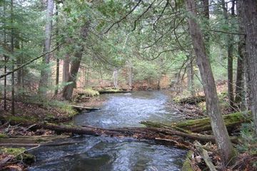
Photo by U.S. Forest Service
The focus of this site is Eighteen Mile Creek and its associated tributary Porcupine Creek. These high-quality, mostly closed-canopy, trout streams originate from Diamond Lake and Porcupine Lake respectively. Porcupine Lake is a relatively undisturbed drainage lake within a designated Wilderness Area. The stream banks are forested with excellent to good quality stands of hemlock-dominated forest with a significant upland cedar, yellow birch, and super-canopy white pine component and occasional patches of Canada yew and hemlock saplings. A shaded cliff community towers over Eighteen Mile Creek as it flows from its headwaters south of the Penokee-Gogebic range to Lake Superior.
The granite cliffs rise from ten to over fifty feet in a series of steps from the creek bottom. The different aspects represented support unique vegetation with south-facing cliffs having a drier, younger overstory while north-facing cliffs are more mesic with an older overstory. Herbaceous cliff species include common polypody, fragile fern, intermediate wood fern, common oak fern, maidenhair fern, pale corydalis, and zig-zag goldenrod. Uncommon species present are fragrant fern and purple clematis. Uplands include a relatively large stand of hemlock-hardwood forest near the headwaters of Porcupine Creek and on the shoreline of Porcupine Lake as well as pockets of old-growth hemlock-hardwoods near the headwaters of Eighteenmile Creek, south of Coburn Lake, and west of Sage Lake.
Small stands of northern dry-mesic forest dominated by red and white pine occur on isolated bedrock outcrops along the stream corridor and near Deer Lick Lake. Red oak is occasionally present. Mature, mixed northern hardwoods with scattered residual stems comprise the balance of the uplands on the site. A large portion of this site lies within the Porcupine Lake Wilderness Area and includes a small stretch of the North Country Scenic Trail. Also of primary importance is the shared boundary with the Lake Owen complex along the Great Divide-Washburn District boundary. These two sites, when combined with the Porcupine Lake Wilderness Area form one of the largest blocks of mature hardwood forest remaining in the Forest. Eighteen Mile Creek is owned by the US Forest Service and was designated a State Natural Area in 2007.
Very few State Natural Areas have public facilities, but nearly all are open for a variety of recreational activities as indicated below. Generally, there are no picnic areas, restrooms, or other developments. Parking lots or designated parking areas are noted on individual SNA pages and maps. If a developed trail is present, it will normally be noted on the SNA map and/or under the Maps tab. A compass and topographic map or a GPS unit are useful tools for exploring larger, isolated SNAs.
The good majority of SNAs are isolated and have few or no facilities. Some SNAs have vehicle access lanes or parking lots, but their accessibility may vary depending on weather conditions. Parking lots and lanes are not plowed during winter. Hiking trails may be nonexistent or consist of undeveloped footpaths. A GPS unit or compass and a detailed topographic map are useful tools for exploring larger SNAs.
Non-DNR lands
Entrance fees: For non-DNR-owned SNAs, we are unaware of any vehicle or admission fees. However, please contact the landowner for more information.
Hunting and trapping
Other activities
Other allowable activities such as - but not limited to camping, geocaching and bicycling are determined by the landowner. Please contact them directly or visit their websites for details.
Location
Within the Chequamegon-Nicolet National Forest, Bayfield County. T44N-R6W, Sections 5, 6, 8, 17, 18, 19, 30. 1,595 acres.
Driving directions
From the town of Grand View, go south on Highway D for about 4 miles, then west on FR 213 for about 3.5 miles to where Eighteenmile Creek crosses the road. Follow the stream north or south into the site.
The DNR's state natural areas program is comprised of lands owned by the state, private conservation organizations, municipalities, other governmental agencies, educational institutions and private individuals. While the majority of SNAs are open to the public, access may vary according to individual ownership policies. Public use restrictions may apply due to public safety, or to protect endangered or threatened species or unique natural features. Lands may be temporarily closed due to specific management activities.
Users are encouraged to contact the landowner for more specific details. The data shown on these maps have been obtained from various sources, and are of varying age, reliability, and resolution. The data may contain errors or omissions and should not be interpreted as a legal representation of legal ownership boundaries. To create your custom map where you can zoom to a specific location, please use the DNR's Mapping Application.
Eighteen Mile Creek is owned by: US Forest Service