Echo Lake
No. 445
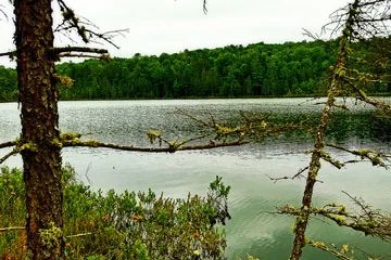
Photo by Aaron Carlson
Echo Lake features a soft seepage lake and bog mat, and several stands of mature hemlock hardwoods situated on rolling moraine, which is among the oldest and least disturbed on the Nicolet. Most of the stand is dominated by large hemlock (45 inches in diameter) with yellow birch and sugar maple. Other species include basswood, white pine, and white spruce. The understory is open with few shrubs and local small canopy gaps filled with sugar maple saplings.
The ground layer is dense in some areas and contains uncommon ginseng. Characteristic species include jack-in-the-pulpit, shining club-moss, intermediate wood fern, three-leaved goldthread, and blue cohosh. Coarse woody debris and large snags are common giving a pronounced old-growth feel to the site. The mature forest provides nesting habitat for numerous neotropical migrant birds including the black-throated blue warbler. Also present is a mosaic of wetland types which includes a northern wet forest dominated by black spruce and tamarack, white cedar swamp, alder thicket, and open bog. Black spruce and tamarack dominate in the wetter areas to the south and east giving way to white cedar in the north part of the stands.
Red maple also occurs in places. Although some cedar cutting has occurred in the past, regeneration is excellent in places and much has already outgrown the browse level. The open bog surrounding Echo Lake supports an excellent representation of ericaceous species including Labrador tea, velvet-leaf blueberry, bog laurel and leather-leaf. Abundant herbaceous plants include the moccasin flower, false mayflower, pitcher plant, marsh marigold, and naked miterwort. The gray jay(Perisoreus canadensis), an uncommon bird species, is present here. Other breeding birds found within the site are the least flycatcher, olive-sided flycatcher, blue-headed vireo, wood thrush, blackburnian warbler, northern warbler, ovenbird, and scarlet tanager. Echo Lake is owned by the U.S. Forest Service and was designated a State Natural Area in 2007. This site is also recognized by the Forest Service as an established Research Natural Area.
Very few State Natural Areas have public facilities, but nearly all are open for a variety of recreational activities as indicated below. Generally, there are no picnic areas, restrooms, or other developments. Parking lots or designated parking areas are noted on individual SNA pages and maps. If a developed trail is present, it will normally be noted on the SNA map and/or under the Maps tab. A compass and topographic map or a GPS unit are useful tools for exploring larger, isolated SNAs.
The good majority of SNAs are isolated and have few or no facilities. Some SNAs have vehicle access lanes or parking lots, but their accessibility may vary depending on weather conditions. Parking lots and lanes are not plowed during winter. Hiking trails may be nonexistent or consist of undeveloped footpaths. A GPS unit or compass and a detailed topographic map are useful tools for exploring larger SNAs.
Non-DNR lands
Entrance fees: For non-DNR-owned SNAs, we are unaware of any vehicle or admission fees. However, please contact the landowner for more information.
Hunting and trapping
Other activities
Other allowable activities such as - but not limited to camping, geocaching and bicycling are determined by the landowner. Please contact them directly or visit their websites for details.
Location
Located within the Chequamegon-Nicolet National Forest. Vilas County. T40N-R11E, Section 25; T40N-R12E, Sections 19, 20, 29, 30, 31. 657 acres.
Driving directions
From the intersection of Highways 70 and 32 in Eagle River, go east on 70 for about 12 miles, then south on FR 2460 for 2.6 miles to a parking area west of the road. Trails lead east into the site.
The DNR's state natural areas program comprises lands owned by the state, private conservation organizations, municipalities, other governmental agencies, educational institutions and private individuals. While the majority of SNAs are open to the public, access may vary according to individual ownership policies. Public use restrictions may apply due to public safety, or to protect endangered or threatened species or unique natural features. Lands may be temporarily closed due to specific management activities.
Users are encouraged to contact the landowner for more specific details. The data shown on these maps have been obtained from various sources, and are of varying age, reliability, and resolution. The data may contain errors or omissions and should not be interpreted as a legal representation of legal ownership boundaries. To create your custom map where you can zoom to a specific location, please use the DNR's Mapping Application.
Echo Lake is owned by: US Forest Service