East Fork of the Black River
No. 612
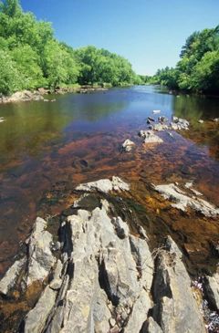
Photo by Thomas A. Meyer/DNR
The East Fork of the Black River is one of the longest stretches of undammed and essentially undeveloped river corridors in the southern 2/3rds of Wisconsin. The southern extremity of the Canadian Shield, or Laurentian Plateau, is exposed here, exemplified by pre-Cambrian granitic bedrock outcroppings that occur along the shores. The site is a biologically significant mosaic of terrestrial and aquatic communities and supports several rare plants and animals. Along with the East Fork proper, the primary features at this site include a series of ridges and swales that parallel the river on its south side. Here, the ridges support a mature dry-mesic forest of white and red pine and oak. The swales contain a variety of wetland communities, including white pine-red maple swamp, tamarack swamp, northern sedge meadow, and alder thicket. These natural communities harbor a diversity of bird species including pine, black-throated green, blackburnian, Nashville, hermit thrush, veery, and northern raven. A state-threatened species also occurs here. The East Fork of the Black River is owned by the DNR and was designated a State Natural Area in 2010.
Very few State Natural Areas have public facilities, but nearly all are open for a variety of recreational activities as indicated below. Generally, there are no picnic areas, restrooms, or other developments. Parking lots or designated parking areas are noted on individual SNA pages and maps. If a developed trail is present, it will normally be noted on the SNA map and/or under the Maps tab. A compass and topographic map or a GPS unit are useful tools for exploring larger, isolated SNAs.
The good majority of SNAs are isolated and have few or no facilities. Some SNAs have vehicle access lanes or parking lots, but their accessibility may vary depending on weather conditions. Parking lots and lanes are not plowed during winter. Hiking trails may be nonexistent or consist of undeveloped footpaths. A GPS unit or compass and a detailed topographic map are useful tools for exploring larger SNAs.
Entrance fees: Except for Parfrey's Glen, the Cambrian Outlook in the Dells of the Wisconsin River, SNAs within State Parks and some within State Forests, all other DNR-owned SNAs do not have any admission fees. For more information, see Wis. Admin. Code NR 45 [exit DNR]. For non-DNR-owned SNAs, we are unaware of any vehicle or admission fees. However, please contact the landowner for more information.
Allowable activities: DNR-owned land
The activities listed below are generally allowed on all DNR-owned SNA lands. Exceptions to this list of public uses, such as SNAs closed to hunting, are noted above and posted with signs on the property site.
- Hiking
- Fishing
- Cross country skiing
- Hunting
- Trapping
- Scientific research (permit required [PDF])
- Outdoor education
- Wild edibles (What is this?)
- Pets (Rules)
- Wildlife viewing
Prohibited activities: all SNAs
Although a handful of sites allow activities like primitive camping (e.g. Lower Chippewa River on sand bars) or horseback riding (e.g. S. Kettle Moraine), the activities listed below are generally prohibited on DNR-owned SNAs.
- Camping and campfires
- Collecting of animals (other than legally harvested species), non-edible fungi, rocks, minerals, fossils, archaeological artifacts, soil, downed wood, or any other natural material, alive or dead.
- Collecting for scientific research requires a permit issued by the DNR
- Collecting of plants including seeds, roots or other non-edible parts of herbaceous plants such as wildflowers or grasses
- Drones: Flying-related activities, including the use of drones, hang-gliders and model airplanes, are prohibited. Permission may be issued by the SNA Program for the use of drones for educational or research purposes
- Geocaching
- Horseback riding
- Rock climbing
- Vehicles, including bicycles, ATVs, aircraft, and snowmobiles except on trails and roadways designated for their use.
For rules governing state-owned SNAs and other state lands, please consult Chapter NR 45 Wis. Admin. Code [exit DNR].
Location
Within the Black River State Forest, Jackson County. T22N-R2W, Sections 5, 6. T23N-R2W, Sections 31, 32. 513 acres.
Driving directions
From the intersection of County E and K in Hatfield, go south on K for 0.7 miles, then east on Clay School Road for 2.3 miles, then north on Campground Road for 1 mile to the East Fork Recreation Area. Park and then follow the East Fork of the Black River east about 0.4 miles. Or for carry-in boat access, from the intersection of County E and K in Hatfield, go south on K for 0.7 miles, then east on Clay School Road for 4.3 miles, then north on East Fork Road for 0.6-mile miles to the boat access site along the East Fork.
The DNR's state natural areas program comprises lands owned by the state, private conservation organizations, municipalities, other governmental agencies, educational institutions and private individuals. While the majority of SNAs are open to the public, access may vary according to individual ownership policies. Public use restrictions may apply due to public safety, or to protect endangered or threatened species or unique natural features. Lands may be temporarily closed due to specific management activities.
Users are encouraged to contact the landowner for more specific details. The data shown on these maps have been obtained from various sources, and are of varying age, reliability, and resolution. The data may contain errors or omissions and should not be interpreted as a legal representation of legal ownership boundaries. To create your custom map where you can zoom to a specific location, please use the DNR's Mapping Application.
East Fork of the Black River is owned by: Wisconsin DNR