Eagle Centre Prairie
No. 349
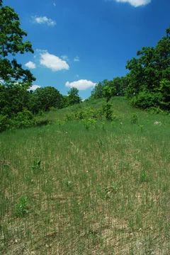
Photo by Josh Mayer
Eagle Centre Prairie features a remnant prairie and bur oak opening situated on broken, gravelly interlobate moraine. Scattered, large, open-grown bur oaks with white and black oak are interspersed with prairie-like openings. A moderate number of native prairie and savanna species have persisted, and those that are especially resistant to grazing can still be found in abundance including pasqueflower, prairie smoke, and a state-threatened plant.
Other species include purple love grass, prairie dropseed, side-oats grama, death camas, purple prairie clover, bird's-foot violet, whorled milkweed, shooting star, showy goldenrod, silky aster, and thimbleweed. Dense thickets of shrubs and saplings occur under large oaks, especially in more mesic draws and kettles. Management practices such as brushing, prescribed burning, and interseeding of native species will help restore and maintain the vigor of the prairie and oak opening. Eagle Centre Prairie is owned by the Waukesha Land Conservancy and was designated a State Natural Area in 2002.
Very few State Natural Areas have public facilities, but nearly all are open for a variety of recreational activities as indicated below. Generally, there are no picnic areas, restrooms, or other developments. Parking lots or designated parking areas are noted on individual SNA pages and maps. If a developed trail is present, it will normally be noted on the SNA map and/or under the Maps tab. A compass and topographic map or a GPS unit are useful tools for exploring larger, isolated SNAs.
The good majority of SNAs are isolated and have few or no facilities. Some SNAs have vehicle access lanes or parking lots, but their accessibility may vary depending on weather conditions. Parking lots and lanes are not plowed during winter. Hiking trails may be nonexistent or consist of undeveloped footpaths. A GPS unit or compass and a detailed topographic map are useful tools for exploring larger SNAs.
Non-DNR lands
Entrance fees: For non-DNR-owned SNAs, we are unaware of any vehicle or admission fees. However, please contact the landowner for more information.
Hunting and trapping
Other activities
Other allowable activities such as - but not limited to camping, geocaching and bicycling are determined by the landowner. Please contact them directly or visit their websites for details.
Location
Waukesha County. T5N-R17E, Section 22. 8 acres.
Driving directions
From the intersection of County NN and South Street in Eagle (just east of Highway 67), go south on South Street for 0.7 miles, then west on Meadow Lane for one block, then south on Clover Court to the cul-de-sac. Park and walk southwest into the site.
The DNR's state natural areas program is comprised of lands owned by the state, private conservation organizations, municipalities, other governmental agencies, educational institutions and private individuals. While the majority of SNAs are open to the public, access may vary according to individual ownership policies. Public use restrictions may apply due to public safety, or to protect endangered or threatened species or unique natural features. Lands may be temporarily closed due to specific management activities.
Users are encouraged to contact the landowner for more specific details. The data shown on these maps have been obtained from various sources, and are of varying age, reliability, and resolution. The data may contain errors or omissions and should not be interpreted as a legal representation of legal ownership boundaries. To create your custom map where you can zoom to a specific location, please use the DNR's Mapping Application.
Eagle Centre Prairie is owned by: Waukesha Land Conservancy