Dwight's Point And Pokegama Wetlands
No. 300
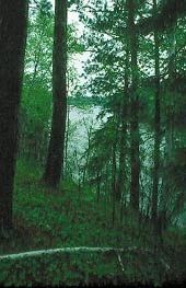
Photo by Thomas A. Meyer/DNR
Located at the confluence of the Pokegama and St. Louis Rivers near Lake Superior, Dwight's Point and Pokegama Wetlands feature boreal forestforestsgent marsh, and wet clay flats supporting shrub swamp swampset meadow. The natural area borders the St. Louis River estuary, which dissects the uplands into a series of narrow, steep-sided ridges, the largest of which is Dwight's Point. Although the boreal forest was cut over at the turn of the 20th century, it remains today as one of the best examples of its type in the Lake Superior area.
The presence and unusual composition of the boreal forest are due to the influence of cool breezes off Lake Superior and the level topography with underlying red clay soils which prevent timely drainage. White pine, paper birch, balsam poplar, white spruce and balsam fir dominate the forest. In some stands, red pine and black ash are important canopy trees. The forest floor is likewise boreal, with yellow blue-bead-lily, three-leaved goldthread, American starflower, shining club moss, and numerous ferns predominating. Two uncommon plants, northern bluebells and rabbit-berry, are also found here. Resident birds include many species associated with mature conifer forests, such as Blackburnian, black-throated green, Cape May and pine warblers.
Extensive deep and shallow marshes border the Pokegama River. Dominant species in the shallows are bur-reed, cat-tail, bulrushes, wild rice, and arrowheads. Deeper waters harbor coon's-tail, pondweeds, and water-lilies. Virginia rail, sora, and marsh wrens are common resident birds in the marsh. The perched wetlands on the clay plain are a community found in Wisconsin only in the Superior area. The slightly undulating topography is vegetated with a mosaic of shrubs (willows, alder), sedges and grasses. Dwight's Point and Pokegama Wetlands are owned by the City of Superior and were designated a State Natural Area in 1994.
Very few State Natural Areas have public facilities, but nearly all are open for a variety of recreational activities as indicated below. Generally, there are no picnic areas, restrooms, or other developments. Parking lots or designated parking areas are noted on individual SNA pages and maps. Trails, if present, are typically undesignated footpaths. If a developed trail is present, it will normally be noted on the SNA map under the Maps tab. A compass and topographic map or a GPS unit are useful tools for exploring larger, isolated SNAs.
The good majority of SNAs are isolated and have few or no facilities. Some SNAs have vehicle access lanes or parking lots, but their accessibility may vary depending on weather conditions. Parking lots and lanes are not plowed during winter. Hiking trails may be nonexistent or consist of undeveloped footpaths. A GPS unit or compass and a detailed topographic map are useful tools for exploring larger SNAs.
Non-DNR lands
Entrance fees: For non-DNR-owned SNAs, we are unaware of any vehicle or admission fees. However, please contact the landowner for more information.
Hunting and trapping
Other activities
Other allowable activities such as - but not limited to camping, geocaching and bicycling are determined by the landowner. Please contact them directly or visit their websites for details.
Location
Within the Superior Municipal Forest, Douglas County. T48N-R14W, Sections 4, 5, 6. T49N-R14W, Sections 19, 20, 29, 30, 31, 32, 33. 3,153 acres.
Driving directions
From the junction of U.S. Highway 2 and State Highway 35 in Superior, go south on 35 (Tower Ave.) one mile to 28th Street, then west on 28th Street for about 1.75 miles until it becomes Billings Drive. Access is from any number of points along Billings Drive. Several hiking, biking, ski, and snowmobile trails wind through the natural area. The natural area is also accessible by water.
The DNR's state natural areas program is comprised of lands owned by the state, private conservation organizations, municipalities, other governmental agencies, educational institutions and private individuals. While the majority of SNAs are open to the public, access may vary according to individual ownership policies. Public use restrictions may apply due to public safety, or to protect endangered or threatened species or unique natural features. Lands may be temporarily closed due to specific management activities.
Users are encouraged to contact the landowner for more specific details. The data shown on these maps have been obtained from various sources, and are of varying age, reliability, and resolution. The data may contain errors or omissions and should not be interpreted as a legal representation of legal ownership boundaries. To create your custom map where you can zoom to a specific location, please use the DNR's Mapping Application.
Dwight's Point And Pokegama Wetlands are owned by: the City of Superior