Durst Rockshelter
No. 44
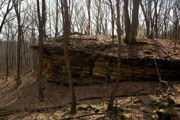
Photo by Josh Mayer
Durst Rockshelter contains an important archeological feature located within a southern mesic forest. A sandstone ridge runs east-west through its center and is forested with red and white oaks, red maple, basswood, and ash. The southern portion of the area is wooded with young maples and contains a diverse groundlayer including several rare species. The southeast-facing rock shelter extends 80 feet along the bluff wall, 50 feet of which affords shelter.
Research excavations found deposits 3 feet thick containing both ceramic and non-ceramic artifacts, showing that different cultural groups have occupied the site. The oldest artifacts were Raddatz side-notched points from Archaic time, which suggests an age of 5500 to 6000 years. Above these were Durst stemmed-type points of the late Archaic and middle and late Woodfordian periods. Durst Rockshelter is owned by the Wisconsin Chapter of The Nature Conservancy and was designated a State Natural Area in 1966.
Location
Sauk County. 40 acres.
Driving directions
Access is restricted - use is by written permission only due to the sensitive nature of the site. Contact the Wisconsin Chapter of The Nature Conservancy for more information.
Durst Rockshelter is owned by: The Nature Conservancy