Dunbar Barrens
No. 104
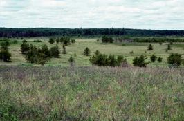
Photo by E. Epstein
Dunbar Barrens features a Pine Barrens community that is part of a large, open landscape located on a gently rolling pitted glacial outwash plain. The site is similar in composition to presettlement barrens with broad sweeping prairie vistas and a distinctive panorama. Logging, grazing and periodic fires have maintained the open character of the barrens in addition to the action of frost in low pockets. Today, aspen, oak and jack pine forest surround the opening and low granitic outcrops are found scattered throughout the area. The dominant vegetation consists of grasses and sedges, and a well-developed shrub layer is present including blueberry, bearberry, prairie willow and sweet fern. Herbaceous plants include rice grass, poverty oat grass, wintergreen, barren strawberry and hawkweeds. The area also harbors a diverse and unusual lichen flora. Originally recognized as a being attractive habitat for sharp-tailed grouse, the bird is today absent from the barrens after a population peak 1950's. The last recorded observation was in 1976. Common barrens birds include the eastern bluebird, eastern towhee, field sparrow and clay-colored sparrow. Dunbar Barrens is owned by the DNR and was designated a State Natural Area in 1973.
Very few State Natural Areas have public facilities, but nearly all are open for various recreational activities as indicated below. Generally, there are no picnic areas, restrooms, or other developments. Parking lots or designated parking areas are noted on individual SNA pages and maps. Trails, if present, are typically undesignated footpaths. If a developed trail is present, it will normally be noted on the SNA map under the Maps tab. A compass and topographic map or a GPS unit are useful tools for exploring larger, isolated SNAs.
The good majority of SNAs are isolated and have few or no facilities. Some SNAs have vehicle access lanes or parking lots, but their accessibility may vary depending on weather conditions. Parking lots and lanes are not plowed during winter. Hiking trails may be nonexistent or consist of undeveloped footpaths. A GPS unit or compass and a detailed topographic map are useful tools for exploring larger SNAs.
Entrance fees: Except for Parfrey's Glen, the Cambrian Outlook in the Dells of the Wisconsin River, SNAs within State Parks and some within State Forests, all other DNR-owned SNAs do not have any admission fees. For more information, see Wis. Admin. Code NR 45. For non-DNR-owned SNAs, we are unaware of any vehicle or admission fees. However, please contact the landowner for more information.
Allowable activities: DNR-owned land
The activities listed below are generally allowed on all DNR-owned SNA lands. Exceptions to this list of public uses, such as SNAs closed to hunting, are noted above and posted with signs on the property site.
- Hiking
- Fishing
- Cross country skiing
- Hunting
- Trapping
- Scientific research (permit required)
- Outdoor education
- Wild edibles (What is this?)
- Pets (Rules)
- Wildlife viewing
Prohibited activities: all SNAs
- Camping and campfires
- Collecting of animals (other than legally harvested species), non-edible fungi, rocks, minerals, fossils, archaeological artifacts, soil, downed wood, or any other natural material alive or dead.
- Collecting for scientific research requires a permit issued by the DNR
- Collecting of plants including seeds, roots or other non-edible parts of herbaceous plants such as wildflowers or grasses
- Geocaching
- Horseback riding
- Rock climbing
- Vehicles, including bicycles, ATVs, aircraft, and snowmobiles except on trails and roadways designated for their use.
For rules governing state-owned SNAs and other state lands, please consult Chapter NR 45 Wis. Admin. Code [exit DNR].
Location
Marinette County. T37N-R18E, Sections 16, 17, 20, 21, 28. 1,412 acres.
Driving directions
From the intersection of U.S. Highway 8 and County U west of Dunbar, go west on 8 2.0 miles, then north on an unimproved access road (marked with fire number 12902) 1.3 miles, then west 0.4 miles to the southeast corner of the site.
The DNR's state natural areas program comprises lands owned by the state, private conservation organizations, municipalities, other governmental agencies, educational institutions, and private individuals. While most SNAs are open to the public, access may vary according to individual ownership policies. Public use restrictions may apply due to public safety, or to protect endangered or threatened species or unique natural features. Lands may be temporarily closed due to specific management activities.
Users are encouraged to contact the landowner for more specific details. The data shown on these maps have been obtained from various sources, and are of varying age, reliability, and resolution. The data may contain errors or omissions and should not be interpreted as a legal representation of legal ownership boundaries. To create your custom map where you can zoom to a specific location, please use the DNR's Mapping Application.
Dunbar Barrens is owned by: Wisconsin DNR