Dry Lake
No. 424
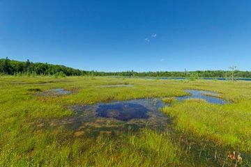
Photo by Josh Mayer
Dry Lake features intact, older second-growth upland hemlock-hardwoods surrounded by a fringe of hemlock and cedar forest. Locally (within Morse Township) as well as regionally, this forest type historically dominated the landscape and today is nearly gone in its original form. Also present is an extensive open wiregrass poor fen and tussock sedge meadow surrounding a spring-fed bog lake, northern wet forest, and a rocky-bottomed, shaded stream stretch that is a tributary to the Bad River. Although lightly managed about 20 years ago, the uplands are now approaching an old-growth state and the forest supports other old-growth attributes including snags, and coarse woody debris, along with ephemeral ponds and intact gradient from upland to lowland. Sugar maple, yellow birch, and hemlock dominate the uplands with a sparse midstory and shrub layer. A few widely scattered super canopy white pine and white spruce are present. Canopy associates include balsam fir, red maple, white cedar, and ironwood.
The ground flora is typical of the ATO habitat type with wood fern, lady fern, and species of the lily family. A nice gradient exists from the uplands down to the open sedge meadow. Common understory plants include leather-leaf, tussock sedge, bladderwort, cat-tail, wild calla, crested shield fern, small cranberry, mountain holly, marsh bellflower, and marsh cinquefoil. Surrounding Dry Lake are open wetlands that represent the best examples of poor fen and sedge meadow on the Valhalla/Marenisco Moraines Landtype on the Forest and provide excellent habitat for unique flora and fauna. Plants characteristic of poor fens, bogs and marshes are present including tamarack, sphagnum, leatherleaf, tussock sedge, willow, and cat-tails. The north side of the lake is characterized by a tussock sedge and a blue-joint grass meadow. The wetlands on the south side of the lake represent a unique poor fen community with boreal bog sedges, creeping sedges, white beak rush, and cotton grasses. The conifer swamp is patchy with alder and mixed northern white cedar, hemlock, and black ash. The ground flora includes dewberry, three-leaved goldthread, mountain wood sorrel, and ferns. Dry Lake is owned by the U.S. Forest Service and was designated a State Natural Area in 2007. This site is also recognized by the Forest Service as an established Research Natural Area.
Very few State Natural Areas have public facilities, but nearly all are open for a variety of recreational activities as indicated below. Generally, there are no picnic areas, restrooms, or other developments. Parking lots or designated parking areas are noted on individual SNA pages and maps. If a developed trail is present, it will usually be noted on the SNA map and/or under the Maps tab. A compass and topographic map or a GPS unit are useful tools for exploring larger, isolated SNAs.
The good majority of SNAs are isolated and have few or no facilities. Some SNAs have vehicle access lanes or parking lots, but their accessibility may vary depending on weather conditions. Parking lots and lanes are not plowed during winter. Hiking trails may be nonexistent or consist of undeveloped footpaths. A GPS unit or compass and a detailed topographic map are useful tools for exploring larger SNAs.
Non-DNR lands
Entrance fees: For non-DNR-owned SNAs, we are unaware of any vehicle or admission fees. However, please contact the landowner for more information.
Hunting and trapping
Other activities
Other allowable activities such as - but not limited to camping, geocaching and bicycling are determined by the landowner. Please contact them directly or visit their websites for details.
Location
Within the Chequamegon-Nicolet National Forest, Ashland County. T43N-R2W, Sections 1, 2, 11, 12. 358 acres.
Driving directions
The site is located approximately 5.5 miles north of Glidden, Wisconsin. Access is via County Highway X to FR 357 (Old Morse Road), then to FR 358 (Dry Lake Rd). Take FR 358 2 miles. The site lies east of the road.
The DNR's state natural areas program is comprised of lands owned by the state, private conservation organizations, municipalities, other governmental agencies, educational institutions and private individuals. While the majority of SNAs are open to the public, access may vary according to individual ownership policies. Public use restrictions may apply due to public safety, or to protect endangered or threatened species or unique natural features. Lands may be temporarily closed due to specific management activities.
Users are encouraged to contact the landowner for more specific details. The data shown on these maps have been obtained from various sources, and are of varying age, reliability, and resolution. The data may contain errors or omissions and should not be interpreted as a legal representation of legal ownership boundaries. To create your custom map where you can zoom to a specific location, please use the DNR's Mapping Application.
Dry Lake is owned by: U.S. Forest Service