Drummond Woods
No. 427
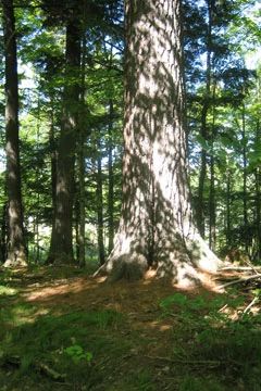
Photo by U.S. Forest Service
Drummond Woods contains older-growth northern mesic hardwoods with a significant hemlock component, often with diameters up to 40 inches. On hummocky, rolling terrain is a hemlock-dominated old-growth forest with super-canopy white and red pine, large snags, and coarse woody debris. Associated hardwoods include sugar maple, yellow birch, paper birch, and basswood. Wet pockets of black ash and red maple are present, as are a few scattered ephemeral ponds. The understory is sparse with tree saplings and American fly honeysuckle, beaked hazelnut, and leatherwood.
Characteristic herbs include Canada mayflower, intermediate wood fern, northern tree club-moss, shining club-moss, and rough-leaved rice cut grass. Wetter areas with a hemlock canopy have a ground layer of three-leaved goldthread, mountain wood sorrel, and yellow blue-bead lily. The site is easily accessible by US Highway 63 and has both an interpretive trail and a portion of the North Country Scenic Trail allowing easy access for the public to view and enjoy old-growth forest. Other important features include hemlock regeneration in early successional forests; ephemeral ponds; and super canopy white pine. Drummond Woods is owned by the US Forest Service and was designated a State Natural Area in 2007.
Very few State Natural Areas have public facilities, but nearly all are open for a variety of recreational activities as indicated below. Generally, there are no picnic areas, restrooms, or other developments. Parking lots or designated parking areas are noted on individual SNA pages and maps. If a developed trail is present, it will usually be noted on the SNA map and/or under the Maps tab. A compass and topographic map or a GPS unit are useful tools for exploring larger, isolated SNAs.
The good majority of SNAs are isolated and have few or no facilities. Some SNAs have vehicle access lanes or parking lots, but their accessibility may vary depending on weather conditions. Parking lots and lanes are not plowed during winter. Hiking trails may be nonexistent or consist of undeveloped footpaths. A GPS unit or compass and a detailed topographic map are useful tools for exploring larger SNAs.
Non-DNR lands
Entrance fees: For non-DNR-owned SNAs, we are unaware of any vehicle or admission fees. However, please contact the landowner for more information.
Hunting and trapping
Other activities
Other allowable activities such as - but not limited to camping, geocaching and bicycling are determined by the landowner. Please contact them directly or visit their websites for details.
Location
Within the Chequamegon-Nicolet National Forest, Bayfield County. T45N-R7W, Sections 23, 25-28, 33-36. 2,361 acres.
Driving directions
At Drummond, go east on US Highway 63 2.2 miles. The site lies north and south of the highway and is located along both sides of Highway 63 starting at the north edge of Drummond and extending north along the highway for four miles.
The DNR's state natural areas program is comprised of lands owned by the state, private conservation organizations, municipalities, other governmental agencies, educational institutions and private individuals. While the majority of SNAs are open to the public, access may vary according to individual ownership policies. Public use restrictions may apply due to public safety, or to protect endangered or threatened species or unique natural features. Lands may be temporarily closed due to specific management activities.
Users are encouraged to contact the landowner for more specific details. The data shown on these maps have been obtained from various sources, and are of varying age, reliability, and resolution. The data may contain errors or omissions and should not be interpreted as a legal representation of legal ownership boundaries. To create your custom map where you can zoom to a specific location, please use the DNR's Mapping Application.
Drummond Woods is owned by: U.S. Forest Service