Dorothy Lake
No. 630
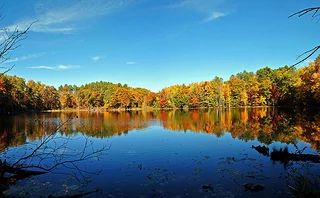
Photo by Aaron Carlson
Dorothy Lake features a diverse mosaic of natural communities and supports numerous rare plant and animal species. Dorothy Lake is a 5.2-acre soft-water seepage lake and supports an extremely diverse invertebrate fauna. A small, soft-water unnamed lake is found just north of Dorothy Lake in an open wetland with an intermittent outlet into Mud Creek. Two other unnamed lakes are located just south of Dorothy Lake, the smallest of which supports a high-quality floating poor fen border. Surrounding the lakes is a northern dry-mesic forest with mature white pine, red pine, and red oak. High-quality wetlands between and adjacent to the lakes are rich in plant species diversity. Four rare plants are supported here. Dorothy Lake is owned by Chippewa County and was designated a State Natural Area in 2010.
Very few State Natural Areas have public facilities, but nearly all are open for a variety of recreational activities as indicated below. Generally, there are no picnic areas, restrooms, or other developments. Parking lots or designated parking areas are noted on individual SNA pages and maps. If a developed trail is present, it will usually be noted on the SNA map and/or under the Maps tab. A compass and topographic map or a GPS unit are useful tools for exploring larger, isolated SNAs.
The good majority of SNAs are isolated and have few or no facilities. Some SNAs have vehicle access lanes or parking lots, but their accessibility may vary depending on weather conditions. Parking lots and lanes are not plowed during winter. Hiking trails may be nonexistent or consist of undeveloped footpaths. A GPS unit or compass and a detailed topographic map are useful tools for exploring larger SNAs.
Non-DNR lands
Entrance fees: For non-DNR-owned SNAs, we are unaware of any vehicle or admission fees. However, please contact the landowner for more information.
Hunting and trapping
Other activities
Other allowable activities such as - but not limited to camping, geocaching and bicycling are determined by the landowner. Please contact them directly or visit their websites for details.
Location
Within the Chippewa County Forest, Chippewa County. T32N-R8W, Section 25. 95 acres.
Driving directions
From the intersection of State Highway 64 and County CC in Cornell, go north on County CC for 5.3 miles, then west on County M for 5.7 miles, then south on Deer Fly Trail for 1.8 miles. Walk west into the site.
The DNR's state natural areas program is comprised of lands owned by the state, private conservation organizations, municipalities, other governmental agencies, educational institutions and private individuals. While the majority of SNAs are open to the public, access may vary according to individual ownership policies. Public use restrictions may apply due to public safety, or to protect endangered or threatened species or unique natural features. Lands may be temporarily closed due to specific management activities.
Users are encouraged to contact the landowner for more specific details. The data shown on these maps have been obtained from various sources, and are of varying age, reliability, and resolution. The data may contain errors or omissions and should not be interpreted as a legal representation of legal ownership boundaries. To create your custom map where you can zoom to a specific location, please use the DNR's Mapping Application.
Dorothy Lake is owned by: Chippewa County