Diamond Lake
No. 339
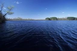
Photo by Thomas A. Meyer/DNR
Diamond Lake has a small county park facility on the west side while the rest of the lake is wild and features a diverse and productive fish population. The 48-acre softwater lake has a maximum depth of 30 feet and is located on Diamond Creek, a feeder to McKenzie Creek. Associated wetlands of the lake include open bog, marsh, and lowland swamp conifers and the lake contains a diversity of aquatic plants, which include cat-tails, pickerel weed, yellow and white water-lily, water-shield, and coon's-tail. Uplands surrounding the lake consist of mixed hardwoods and pastures.
The lake contains a diverse game fish community consisting of walleye, largemouth bass, northern pike, bluegill, black crappie, yellow perch, and pumpkinseed. Non-game fish species include black bullhead, brook lamprey, johnny darter, common shiner, and white sucker. Walleye spawning habitat is found both in the lake and up and downstream in Diamond Creek.
While some walleye have been stocked in the past, the largemouth bass and northern pike consist of naturally reproducing populations. Diamond Lake's natural undisturbed shoreline provides a unique and uninterrupted corridor for many shoreline edge species and many animals including muskrats, weasels, and otter otters area. Diamond Lake is owned by the DNR and was designated a State Natural Area in 2002.
Very few State Natural Areas have public facilities, but nearly all are open for various recreational activities as indicated below. Generally, there are no picnic areas, restrooms, or other developments. Parking lots or designated parking areas are noted on individual SNA pages and maps. Trails, if present, are typically undesignated footpaths. If a developed trail is present, it will normally be noted on the SNA map under the Maps tab. A compass and topographic map or a GPS unit are useful tools for exploring larger, isolated SNAs.
The good majority of SNAs are isolated and have few or no facilities. Some SNAs have vehicle access lanes or parking lots, but their accessibility may vary depending on weather conditions. Parking lots and lanes are not plowed during winter. Hiking trails may be nonexistent or consist of undeveloped footpaths. A GPS unit or compass and a detailed topographic map are useful tools for exploring larger SNAs.
Entrance fees: Except for Parfrey's Glen, the Cambrian Outlook in the Dells of the Wisconsin River, SNAs within State Parks and some within State Forests, all other DNR-owned SNAs do not have any admission fees. For more information, see Wis. Admin. Code NR 45. For non-DNR-owned SNAs, we are unaware of any vehicle or admission fees. However, please contact the landowner for more information.
Allowable activities: DNR-owned land
The activities listed below are generally allowed on all DNR-owned SNA lands. Exceptions to this list of public uses, such as SNAs closed to hunting, are noted above and posted with signs on the property site.
- Hiking
- Fishing
- Cross country skiing
- Hunting
- Trapping
- Scientific research (permit required)
- Outdoor education
- Wild edibles (What is this?)
- Pets (Rules)
- Wildlife viewing
Prohibited activities: all SNAs
- Camping and campfires
- Collecting of animals (other than legally harvested species), non-edible fungi, rocks, minerals, fossils, archaeological artifacts, soil, downed wood, or any other natural material alive or dead.
- Collecting for scientific research requires a permit issued by the DNR
- Collecting of plants including seeds, roots or other non-edible parts of herbaceous plants such as wildflowers or grasses
- Geocaching
- Horseback riding
- Rock climbing
- Vehicles, including bicycles, ATVs, aircraft, and snowmobiles except on trails and roadways designated for their use.
For rules governing state-owned SNAs and other state lands, please consult Chapter NR 45 Wis. Admin. Code [exit DNR].
Location
Taylor County. T30N-R2W, Section 6. T30-R3W, Section 1. 252 acres.
Driving directions
From the intersection of State Highways 64 and 13 in Medford, go west on Highway 64 for 19.5 miles, then south on County Highway F for 0.9 miles, then east on Diamond Drive for 0.75 miles, then north on Lake Drive to the lake.
The DNR's state natural areas program comprises lands owned by the state, private conservation organizations, municipalities, other governmental agencies, educational institutions, and private individuals. While most SNAs are open to the public, access may vary according to individual ownership policies. Public use restrictions may apply due to public safety, or to protect endangered or threatened species or unique natural features. Lands may be temporarily closed due to specific management activities.
Users are encouraged to contact the landowner for more specific details. The data shown on these maps have been obtained from various sources, and are of varying age, reliability, and resolution. The data may contain errors or omissions and should not be interpreted as a legal representation of legal ownership boundaries. To create your custom map where you can zoom to a specific location, please use the DNR's Mapping Application.
Diamond Lake is owned by: Wisconsin DNR