Dewey Marsh
No. 182
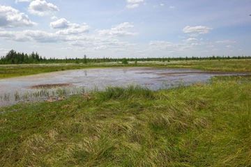
Photo by Ryan O'Connor
Dewey Marsh contains a large expanse of relatively undisturbed northern sedge meadows including smaller islands of tamarack and black spruce swamp, paper birch and white pine woods, and ericaceous bog. The marsh is dominated by blue-joint grass, steeple bush and wire-leaved sedges, with cat-tails and bur-reed. It forms the headwaters of Hay Meadow Creek. Scattered throughout the area are islands of aspen, birch, and white pine.
Tamarack and black spruce swamps are also present. The eastern arm of the marsh is relatively cold and acidic containing an ericaceous bog while the western and southern portions are more alkaline. Rocks are exposed in many areas and there is little peat formation under the sedge mat. Large areas of peat and several acres of tamarack-spruce swamp, shrub carr, and red oak-white pine forest were destroyed in a large fire in 1976. Wildlife use is extensive with a diversity of rare species. Dewey Marsh is owned by the DNR and was designated a State Natural Area in 1976.
Very few State Natural Areas have public facilities, but nearly all are open for various recreational activities as indicated below. Generally, there are no picnic areas, restrooms, or other developments. Parking lots or designated parking areas are noted on individual SNA pages and maps. Trails, if present, are typically undesignated footpaths. If a developed trail is present, it will normally be noted on the SNA map under the Maps tab. A compass and topographic map or a GPS unit are useful tools for exploring larger, isolated SNAs.
The good majority of SNAs are isolated and have few or no facilities. Some SNAs have vehicle access lanes or parking lots, but their accessibility may vary depending on weather conditions. Parking lots and lanes are not plowed during winter. Hiking trails may be nonexistent or consist of undeveloped footpaths. A GPS unit or compass and a detailed topographic map are useful tools for exploring larger SNAs.
Entrance fees: Except for Parfrey's Glen, the Cambrian Outlook in the Dells of the Wisconsin River, SNAs within State Parks and some within State Forests, all other DNR-owned SNAs do not have any admission fees. For more information, see Wis. Admin. Code NR 45. For non-DNR-owned SNAs, we are unaware of any vehicle or admission fees. However, please contact the landowner for more information.
Allowable activities: DNR-owned land
The activities listed below are generally allowed on all DNR-owned SNA lands. Exceptions to this list of public uses, such as SNAs closed to hunting, are noted above and posted with signs on the property site.
- Hiking
- Fishing
- Cross country skiing
- Hunting
- Trapping
- Scientific research (permit required)
- Outdoor education
- Wild edibles (What is this?)
- Pets (Rules)
- Wildlife viewing
Prohibited activities: all SNAs
- Camping and campfires
- Collecting of animals (other than legally harvested species), non-edible fungi, rocks, minerals, fossils, archaeological artifacts, soil, downed wood, or any other natural material alive or dead.
- Collecting for scientific research requires a permit issued by the DNR
- Collecting of plants including seeds, roots or other non-edible parts of herbaceous plants such as wildflowers or grasses
- Geocaching
- Horseback riding
- Rock climbing
- Vehicles, including bicycles, ATVs, aircraft, and snowmobiles except on trails and roadways designated for their use.
For rules governing state-owned SNAs and other state lands, please consult Chapter NR 45 Wis. Admin. Code [exit DNR].
Location
Within Dewey Marsh Wildlife Area, Portage County. T25N-R8E, Sections 10, 11, 14, 15. 801 acres.
Driving directions
From the intersection of I-39 and Business Highway 51 on the north end of Stevens Point, go north on I39 for about 9.1 miles, then east on County DB for 1.9 miles, then south on County Highway X 0.7 miles, then east on Oakwood Drive 2.7 miles, then south on Hay Meadow Drive 0.8 mile to the southwest corner of the site. Park along the road.
The DNR's state natural areas program comprises lands owned by the state, private conservation organizations, municipalities, other governmental agencies, educational institutions, and private individuals. While most SNAs are open to the public, access may vary according to individual ownership policies. Public use restrictions may apply due to public safety, or to protect endangered or threatened species or unique natural features. Lands may be temporarily closed due to specific management activities.
Users are encouraged to contact the landowner for more specific details. The data shown on these maps have been obtained from various sources, and are of varying age, reliability, and resolution. The data may contain errors or omissions and should not be interpreted as a legal representation of legal ownership boundaries. To create your custom map where you can zoom to a specific location, please use the DNR's Mapping Application.
Dewey Marsh is owned by: Wisconsin DNR