Devil's Backbone (Chase Creek)
No. 640
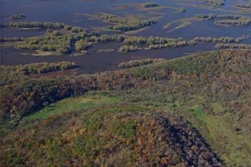
Photo by Thomas A. Meyer/DNR
Devil's Backbone supports several Driftless Area features on 126 acres located between Wyalusing and Nelson Dewey State Parks. A precipitous ridge, which slopes down to the Mississippi River on the west and into the Chase Creek valley to the east, creates the steep-sided "spine" that gives the Devil's Backbone its name. The limestone-capped bluff lies 300' above the Mississippi's floodplain and is vegetated with a deciduous forest of oak, maple and basswood. Near the base of the bluff, along Dugway Road, is a woodland dominated by the uncommon chinquapin oak. Dolomite rock outcrops harbor ferns and wildflowers, including the amethyst shooting star, a showy, magenta-colored beauty that blooms in May.
The sweeping vista of the river valley from the top of the bluff is striking. To the east, the natural area protects a nearly mile-long stretch of Chase Creek, a cool, spring-fed, Class II trout stream. The upland adjacent to the stream valley contains a southern mesic forest recovering from selective timber harvests. A tiny algific talus slope, characterized by fractured blocks of limestone bedrock that emanate refrigerated air throughout the year, is found perched on a shaded hillside. The cool microhabitat of the slope provides a habitat for several uncommon periglacial relict plants and animals. Devil's Backbone is owned by the Mississippi Valley Conservancy and was designated a State Natural Area in 2011. It was formerly known as the Chase Creek State Natural Area.
Very few State Natural Areas have public facilities, but nearly all are open for a variety of recreational activities as indicated below. Generally, there are no picnic areas, restrooms, or other developments. Parking lots or designated parking areas are noted on individual SNA pages and maps. If a developed trail is present, it will normally be noted on the SNA map and/or under the Maps tab. A compass and topographic map or a GPS unit are useful tools for exploring larger, isolated SNAs.
The good majority of SNAs are isolated and have few or no facilities. Some SNAs have vehicle access lanes or parking lots, but their accessibility may vary depending on weather conditions. Parking lots and lanes are not plowed during winter. Hiking trails may be nonexistent or consist of undeveloped footpaths. A GPS unit or compass and a detailed topographic map are useful tools for exploring larger SNAs.
Non-DNR lands
Entrance fees: For non-DNR-owned SNAs, we are unaware of any vehicle or admission fees. However, please contact the landowner for more information.
Hunting and trapping
Other activities
Other allowable activities such as - but not limited to camping, geocaching and bicycling are determined by the landowner. Please contact them directly or visit their websites for details.
Location
Grant County. T4N-R6W, Sections 2, 3. 124 acres.
Driving directions
From Glen Haven, go north on Dugway Road for 1.2 miles. Small Mississippi Valley Conservancy signs mark the boundaries of the property along the road. Park on the roadside and walk up the very steep slope into the preserve.
The DNR's state natural areas program is comprised of lands owned by the state, private conservation organizations, municipalities, other governmental agencies, educational institutions and private individuals. While the majority of SNAs are open to the public, access may vary according to individual ownership policies. Public use restrictions may apply due to public safety, or to protect endangered or threatened species or unique natural features. Lands may be temporarily closed due to specific management activities.
Users are encouraged to contact the landowner for more specific details. The data shown on these maps have been obtained from various sources, and are of varying age, reliability, and resolution. The data may contain errors or omissions and should not be interpreted as a legal representation of legal ownership boundaries. To create your custom map where you can zoom to a specific location, please use the DNR's Mapping Application.
Devil's Backbone (Chase Creek) is owned by: Mississippi Valley Conservancy