Detroit Harbor
No. 413
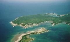
Photo by Door County Land Trust
Detroit Harbor State Natural Area features a diverse complex of intermittent, emergent, and forested wetlands that support numerous rare species. Of primary significance is the presence of the federally endangered Hine's emerald dragonfly (Somatochlora hineana) and the federally threatened dwarf lake iris (Iris lacustris). The natural area also includes Richter Bayou, which is a significant smallmouth bass nursery. The bayou and bulrush flats located within Detroit Island are one of the most productive spawning sites for smallmouth bass in northern Green Bay.
Intermittent wetlands at the north end of the Richter Bayou are fed by a series of groundwater springs that drain south through a network of channels into an open wetland and ultimately into Detroit Harbor. North of the Bayou is dolomitic soils that support a large cedar swamp and an old northern mesic forest dominated by northern white cedar and eastern hemlock. Other trees include American beech, sugar maple, balsam fir, yellow birch, and paper birch. Canada yew (Taxus canadensis), a declining species sensitive to deer browse, is found in the understory. This area is an important migratory stopover site and breeding habitat for numerous rare and uncommon bird species including redhead duck, American white pelican, bald eagle, and red-breasted merganser. Detroit Harbor State Natural Area is owned by the Door County Land Trust and was designated a State Natural Area in 2005.
Very few State Natural Areas have public facilities, but nearly all are open for a variety of recreational activities as indicated below. Generally, there are no picnic areas, restrooms, or other developments. Parking lots or designated parking areas are noted on individual SNA pages and maps. If a developed trail is present, it will usually be noted on the SNA map and/or under the Maps tab. A compass and topographic map or a GPS unit are useful tools for exploring larger, isolated SNAs.
The good majority of SNAs are isolated and have few or no facilities. Some SNAs have vehicle access lanes or parking lots, but their accessibility may vary depending on weather conditions. Parking lots and lanes are not plowed during winter. Hiking trails may be nonexistent or consist of undeveloped footpaths. A GPS unit or compass and a detailed topographic map are useful tools for exploring larger SNAs.
Non-DNR lands
Entrance fees: For non-DNR-owned SNAs, we are unaware of any vehicle or admission fees. However, please contact the landowner for more information.
Hunting and trapping
Other activities
Other allowable activities such as - but not limited to camping, geocaching and bicycling are determined by the landowner. Please contact them directly or visit their websites for details.
Location
Door County. T33N-R29E, Section 11. 117 acres.
Driving directions
From the ferry landing, go east on County W about 2 miles to Green Bay Road. A trailhead is located just south of the intersection of County W (Loebdell Point Road) and Green Bay Road.
The DNR's state natural areas program is comprised of lands owned by the state, private conservation organizations, municipalities, other governmental agencies, educational institutions and private individuals. While the majority of SNAs are open to the public, access may vary according to individual ownership policies. Public use restrictions may apply due to public safety, or to protect endangered or threatened species or unique natural features. Lands may be temporarily closed due to specific management activities.
Users are encouraged to contact the landowner for more specific details. The data shown on these maps have been obtained from various sources, and are of varying age, reliability, and resolution. The data may contain errors or omissions and should not be interpreted as a legal representation of legal ownership boundaries. To create your custom map where you can zoom to a specific location, please use the DNR's Mapping Application.
Detroit Harbor is owned by: Door County Land Trust