Deer Creek Tamarack Bog
No. 659
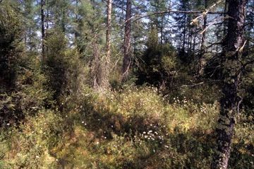
Photo by Emmet Judziewicz
Deer Creek Tamarack Bog supports both remnant tamarack swamp and open bog communities that have remained intact despite their hydrology being altered by ditching many years ago. The best areas feature a densely stocked closed canopy tamarack and black spruce forest with scattered paper birch and white pine.
The open bog is a hummocky, leatherleaf-dominated low shrub community with bog rosemary, Labrador tea, bog laurel, and early low blueberry. The hummocks are comprised of sphagnum moss and are interspersed with cotton grass sedges and other Carex (sedge) species. The herb layer includes crested shield fern, tussock cotton grass, rusty cotton grass, white meadowsweet, steeplebush, cinnamon fern, royal fern, bog St. John’s wort, and flat-topped aster. Deer Creek Tamarack Bog is owned by the DNR and was designated a State Natural Area in 2012.
Very few State Natural Areas have public facilities, but nearly all are open for various recreational activities as indicated below. Generally, there are no picnic areas, restrooms, or other developments. Parking lots or designated parking areas are noted on individual SNA pages and maps. Trails, if present, are typically undesignated footpaths. If a developed trail is present, it will normally be noted on the SNA map under the Maps tab. A compass and topographic map or a GPS unit are useful tools for exploring larger, isolated SNAs.
The good majority of SNAs are isolated and have few or no facilities. Some SNAs have vehicle access lanes or parking lots, but their accessibility may vary depending on weather conditions. Parking lots and lanes are not plowed during winter. Hiking trails may be nonexistent or consist of undeveloped footpaths. A GPS unit or compass and a detailed topographic map are useful tools for exploring larger SNAs.
Entrance fees: Except for Parfrey's Glen, the Cambrian Outlook in the Dells of the Wisconsin River, SNAs within State Parks and some within State Forests, all other DNR-owned SNAs do not have any admission fees. For more information, see Wis. Admin. Code NR 45. For non-DNR-owned SNAs, we are unaware of any vehicle or admission fees. However, please contact the landowner for more information.
Allowable activities: DNR-owned land
The activities listed below are generally allowed on all DNR-owned SNA lands. Exceptions to this list of public uses, such as SNAs closed to hunting, are noted above and posted with signs on the property site.
- Hiking
- Fishing
- Cross country skiing
- Hunting
- Trapping
- Scientific research (permit required)
- Outdoor education
- Wild edibles (What is this?)
- Pets (Rules)
- Wildlife viewing
Prohibited activities: all SNAs
- Camping and campfires
- Collecting of animals (other than legally harvested species), non-edible fungi, rocks, minerals, fossils, archaeological artifacts, soil, downed wood, or any other natural material alive or dead.
- Collecting for scientific research requires a permit issued by the DNR
- Collecting of plants including seeds, roots or other non-edible parts of herbaceous plants such as wildflowers or grasses
- Geocaching
- Horseback riding
- Rock climbing
- Vehicles, including bicycles, ATVs, aircraft, and snowmobiles except on trails and roadways designated for their use.
For rules governing state-owned SNAs and other state lands, please consult Chapter NR 45 Wis. Admin. Code [exit DNR].
Location
Within Deer Creek State Wildlife Area, Outagamie County. T24N-R15E, Sections 1, 2. 293 acres.
Driving directions
From the intersection of Highway 168 and County F in Leeman, go west on County F for 1.7 miles, then continue west on Birch Road for 2.2 miles to a DNR parking area where the road turns south. Park and walk north 0.25 miles to the southwest corner of the SNA.
The DNR's state natural areas program comprises lands owned by the state, private conservation organizations, municipalities, other governmental agencies, educational institutions, and private individuals. While most SNAs are open to the public, access may vary according to individual ownership policies. Public use restrictions may apply due to public safety, or to protect endangered or threatened species or unique natural features. Lands may be temporarily closed due to specific management activities.
Users are encouraged to contact the landowner for more specific details. The data shown on these maps have been obtained from various sources, and are of varying age, reliability, and resolution. The data may contain errors or omissions and should not be interpreted as a legal representation of legal ownership boundaries. To create your custom map where you can zoom to a specific location, please use the DNR's Mapping Application.
Deer Creek Tamarack Bog is owned by: Wisconsin DNR
Management objectives and prescriptions
- Control invasive exotic species.
- Explore opportunities to restore hydrology and implement it in a careful manner that will not affect dominant tree species.
Lower Wolf River Bottomlands Natural Resources Area Master Plan