Cudahy Woods
No. 351
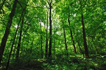
Photo by Josh Mayer
Cudahy Woods features an outstanding example of the hardwood forests that once covered most of Milwaukee County before European settlement and includes dry-mesic, lowland, and mesic forest communities. Occupying the northern portion is a dry-mesic forest dominated by red oak, white oak, black cherry, and shagbark hickory. To the south, the woods are moister and supports an old-growth stand of mesic forest containing sugar maple, American beech, red oak, white ash, and ironwood.
A small stream separates the two forest types and once contained American elm, killed by Dutch elm disease. More than 160 species of native plants are known to inhabit the natural area, among them a state-endangered plant. The forest floor harbors a rich spring flora, including trout lily, Gleason's trillium, blue cohosh, bloodroot, hepatica, and spring beauty. Other species include witch hazel, alternate-leaved dogwood, arrowwood, red and white baneberry, sweet cicely, false Solomon's seal, and wild leek. Cudahy Woods is owned by Milwaukee County and was designated a State Natural Area in 2002.
Very few State Natural Areas have public facilities, but nearly all are open for a variety of recreational activities as indicated below. Generally, there are no picnic areas, restrooms, or other developments. Parking lots or designated parking areas are noted on individual SNA pages and maps. If a developed trail is present, it will normally be noted on the SNA map and/or under the Maps tab. A compass and topographic map or a GPS unit are useful tools for exploring larger, isolated SNAs.
The good majority of SNAs are isolated and have few or no facilities. Some SNAs have vehicle access lanes or parking lots, but their accessibility may vary depending on weather conditions. Parking lots and lanes are not plowed during winter. Hiking trails may be nonexistent or consist of undeveloped footpaths. A GPS unit or compass and a detailed topographic map are useful tools for exploring larger SNAs.
Non-DNR lands
Entrance fees: For non-DNR-owned SNAs, we are unaware of any vehicle or admission fees. However, please contact the landowner for more information.
Hunting and trapping
Other activities
Please see Chapter 47-Parks and Parkways in Milwaukee County's Municipal Code Ch. 47 [exit DNR] for approved recreational uses.
Other allowable activities such as - but not limited to camping, geocaching and bicycling are determined by the landowner. Please contact them directly or visit their websites for details.
Location
Within Milwaukee County Parks, Milwaukee County. T5N-R22E, Section 4, E½ NW¼. 42 acres.
Driving directions
From the junction of I-94 and College Avenue in Milwaukee, go east on College Avenue for 1.4 miles to a gated access and parking area on the south side of the street. Hiking trails provide access to the site.
The DNR's state natural areas program comprises lands owned by the state, private conservation organizations, municipalities, other governmental agencies, educational institutions and private individuals. While the majority of SNAs are open to the public, access may vary according to individual ownership policies. Public use restrictions may apply due to public safety, or to protect endangered or threatened species or unique natural features. Lands may be temporarily closed due to specific management activities.
Users are encouraged to contact the landowner for more specific details. The data shown on these maps have been obtained from various sources, and are of varying age, reliability, and resolution. The data may contain errors or omissions and should not be interpreted as a legal representation of legal ownership boundaries. To create your custom map where you can zoom to a specific location, please use the DNR's Mapping Application.
Cudahy Woods is owned by: Milwaukee County