Cranberry Creek Mound Group
No. 203
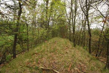
Photo by Josh Mayer
Cranberry Creek Mound Group preserves one of the most significant archeological sites in Wisconsin and one of the largest and best-preserved mound complexes in the Upper Midwest. The site contains excellent examples of conical, linear, oval, and effigy mounds built by Native Americans of the Woodland period (ca. 100-800 A.D.). Although the northern cluster has been altered somewhat by plowing, the southern cluster is unaltered. Among the mounds featured are bear/panther mounds and a 50-foot-long bird effigy mound with a wingspan of 125 feet.
Although the mounds are featured, the site also contains a diversity of natural communities. Along the ditched channel of Cranberry Creek, large river birch and silver and red maples dominate the floodplain forest. Also present is an old-growth northern dry forest with large jack pine and an open pine-oak forest. Since 1917, archaeological investigations of mapping and interpretation have been conducted and the site is part of a larger complex of preserved and protected mounds located in adjacent and nearby areas. Cranberry Creek Mound Group is owned by the DNR and was designated a State Natural Area in 1986.
Very few State Natural Areas have public facilities, but nearly all are open for a variety of recreational activities as indicated below. Generally, there are no picnic areas, restrooms, or other developments. Parking lots or designated parking areas are noted on individual SNA pages and maps. If a developed trail is present, it will normally be noted on the SNA map and/or under the Maps tab. A compass and topographic map or a GPS unit are useful tools for exploring larger, isolated SNAs.
The good majority of SNAs are isolated and have few or no facilities. Some SNAs have vehicle access lanes or parking lots, but their accessibility may vary depending on weather conditions. Parking lots and lanes are not plowed during winter. Hiking trails may be nonexistent or consist of undeveloped footpaths. A GPS unit or compass and a detailed topographic map are useful tools for exploring larger SNAs.
Entrance fees: Excepting Parfrey's Glen, the Cambrian Outlook in the Dells of the Wisconsin River, SNAs within State Parks and some within State Forests, all other DNR-owned SNAs do not have any admission fees. For more information, see Wis. Admin. Code NR 45 [exit DNR]. For non-DNR-owned SNAs, we are unaware of any vehicle or admission fees. However, please contact the landowner for more information.
Allowable activities: DNR-owned land
The activities listed below are generally allowed on all DNR-owned SNA lands. Exceptions to this list of public uses, such as SNAs closed to hunting, are noted above and posted with signs on the property site.
- Hiking
- Fishing
- Cross country skiing
- Hunting
- Trapping
- Scientific research (permit required [PDF])
- Outdoor education
- Wild edibles (What is this?)
- Pets (Rules)
- Wildlife viewing
Prohibited activities: all SNAs
Although a handful of sites allow activities like primitive camping (e.g. Lower Chippewa River on sand bars) or horseback riding (e.g. S. Kettle Moraine), the activities listed below are generally prohibited on DNR-owned SNAs.
- Camping and campfires
- Collecting of animals (other than legally harvested species), non-edible fungi, rocks, minerals, fossils, archaeological artifacts, soil, downed wood, or any other natural material, alive or dead.
- Collecting for scientific research requires a permit issued by the DNR
- Collecting of plants including seeds, roots or other non-edible parts of herbaceous plants such as wildflowers or grasses
- Drones: Flying-related activities, including the use of drones, hang-gliders and model airplanes, are prohibited. Permission may be issued by the SNA Program for the use of drones for educational or research purposes
- Geocaching
- Horseback riding
- Rock climbing
- Vehicles, including bicycles, ATVs, aircraft, and snowmobiles except on trails and roadways designated for their use.
For rules governing state-owned SNAs and other state lands, please consult Chapter NR 45 Wis. Admin. Code [exit DNR].
Location
Juneau County. T20N-R4E, Sections 30, 31. 675 acres.
Driving directions
From the intersection of State Highway 21 and County Highway G east of Necedah, go north on G about 9.8 miles to its junction with County Highway F and 7th Street. Park at the southwest corner of the intersection and walk west along 7th Street into the site. The best mounds are located east of Cranberry Creek, north of the drainage ditch and south of 7th Street. Access also from 8th Street, one mile to the south.
The DNR's state natural areas program comprises lands owned by the state, private conservation organizations, municipalities, other governmental agencies, educational institutions and private individuals. While the majority of SNAs are open to the public, access may vary according to individual ownership policies. Public use restrictions may apply due to public safety, or to protect endangered or threatened species or unique natural features. Lands may be temporarily closed due to specific management activities.
Users are encouraged to contact the landowner for more specific details. The data shown on these maps have been obtained from various sources, and are of varying age, reliability, and resolution. The data may contain errors or omissions and should not be interpreted as a legal representation of legal ownership boundaries. To create your custom map where you can zoom to a specific location, please use the DNR's Mapping Application.
Cranberry Creek Mound Group is owned by: Wisconsin DNR