Coon Fork Barrens
No. 313
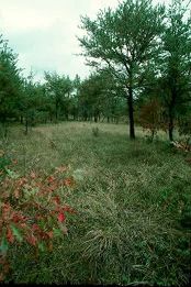
Photo by Thomas A. Meyer/DNR
Coon Fork Barrens features an extensive and diverse barrens community of variable composition and structure located between Coon Fork and Pea Creek, two Eau Claire River tributaries. The gently rolling to flat sandy uplands support barrens that vary from open woodlands with jack pine and oak to open savanna and brush prairie. Jack pine dominates the area with occasional red pine and Hill's, black, white and bur oaks are present mainly as grub trees. Some areas of vegetation are heath-like with species including bracken fern, sweet gale, early low blueberry, American hazelnut and Pennsylvania sedge. Other patches feature a rich sand prairie and savanna flora including big and little blue-stem, June grass, western sunflower, prairie coreopsis, wild lupine, lance-leaved loosestrife, sky-blue aster, prairie goldenrod, rough blazing-star and cylindrical blazing-star. Additionally, the rich, moist low terraces and steep slopes along the creeks support species of white and red pine and red maple. The barrens is critical habitats for a federally endangered butterfly, which is common throughout the area. Wisconsin supports the largest and most widespread population in the world, and is a disturbance-dependent species adapted to barrens and other early successional habitats that have been extirpated from much of its historic range. Thus, the protection and management of areas such as Coon Fork Barrens is critical to its continued survival. Coon Fork Barrens is owned by Eau Claire County and was designated a State Natural Area in 1996.
Very few State Natural Areas have public facilities, but nearly all are open for a variety of recreational activities as indicated below. Generally, there are no picnic areas, restrooms, or other developments. Parking lots or designated parking areas are noted on individual SNA pages and maps. If a developed trail is present, it will normally be noted on the SNA map and/or under the Maps tab. A compass and topographic map or a GPS unit are useful tools for exploring larger, isolated SNAs.
The good majority of SNAs are isolated and have few or no facilities. Some SNAs have vehicle access lanes or parking lots, but their accessibility may vary depending on weather conditions. Parking lots and lanes are not plowed during winter. Hiking trails may be nonexistent or consist of undeveloped footpaths. A GPS unit or compass and a detailed topographic map are useful tools for exploring larger SNAs.
Non-DNR lands
Entrance fees: For non-DNR-owned SNAs, we are unaware of any vehicle or admission fees. However, please contact the landowner for more information.
Hunting and trapping
Other activities
Other allowable activities such as - but not limited to camping, geocaching and bicycling are determined by the landowner. Please contact them directly or visit their websites for details.
Location
Within Eau Claire County Forest. T26N - R5W, Sections 19, 20, 28, 29, 30. 580 acres.
Driving directions
From the intersection of U.S. Highway 12 and County Highway G in Augusta, go east on Highway 12 for 1.6 miles, then northeast on County Highway CF (Coon Fork Road) for 4.2 miles to a parking area just past the creek on the north side of the road. Ski/hiking trails traverse the site.
The DNR's state natural areas program is comprised of lands owned by the state, private conservation organizations, municipalities, other governmental agencies, educational institutions and private individuals. While the majority of SNAs are open to the public, access may vary according to individual ownership policies. Public use restrictions may apply due to public safety, or to protect endangered or threatened species or unique natural features. Lands may be temporarily closed due to specific management activities.
Users are encouraged to contact the landowner for more specific details. The data shown on these maps have been obtained from various sources, and are of varying age, reliability, and resolution. The data may contain errors or omissions and should not be interpreted as a legal representation of legal ownership boundaries. To create your custom map where you can zoom to a specific location, please use the DNR's Mapping Application.
Coon Fork Barrens is owned by: Eau Claire County