Comstock Bog-Meadow
No. 123
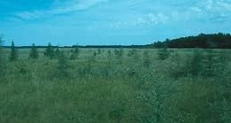
Photo by Thomas A. Meyer/DNR
Lying within a 1000-acre natural basin in the glaciated Central Plain, Comstock Bog-Meadow features a large, quaking sedge meadow marsh with a high diversity of unusual plants. The undisturbed marsh is permanently wet and relatively free of water fluctuations. The south end lies on a drainage divide and is dominated by narrow-leaved sedges with many acid bog plants occurring on the quaking, rhizomatous mat. Of particular interest is the unique assemblage of plants with many characteristic calcareous wetland species growing in association with bog species including twig rush, grass-of-Parnassus, marsh fern, pitcher plant, bladderworts, and sundews. Northward and westward the species composition changes to more closely resemble a sedge meadow. Except for a small area of tamarack, poison sumac, and bog birch, the entire tract is treeless. The marsh is used by a variety of small mammals, muskrats, mink, and birds. Sandhill cranes nest in the marsh and use the area as a fall staging site. In 1851, the original land surveyors described the area as a wet, quaking marsh, "over which we crossed with not a little danger to our lives." Comstock Bog-Meadow is owned by the DNR and was designated a State Natural Area in 1975.
Very few State Natural Areas have public facilities, but nearly all are open for a variety of recreational activities as indicated below. Generally, there are no picnic areas, restrooms, or other developments. Parking lots or designated parking areas are noted on individual SNA pages and maps. If a developed trail is present, it will normally be noted on the SNA map and/or under the Maps tab. A compass and topographic map or a GPS unit are useful tools for exploring larger, isolated SNAs.
The good majority of SNAs are isolated and have few or no facilities. Some SNAs have vehicle access lanes or parking lots, but their accessibility may vary depending on weather conditions. Parking lots and lanes are not plowed during winter. Hiking trails may be nonexistent or consist of undeveloped footpaths. A GPS unit or compass and a detailed topographic map are useful tools for exploring larger SNAs.
Entrance fees: Excepting Parfrey's Glen, the Cambrian Outlook in the Dells of the Wisconsin River, SNAs within State Parks and some within State Forests, all other DNR-owned SNAs do not have any admission fees. For more information, see Wis. Admin. Code NR 45 [exit DNR]. For non-DNR-owned SNAs, we are unaware of any vehicle or admission fees. However, please contact the landowner for more information.
Allowable activities: DNR-owned land
The activities listed below are generally allowed on all DNR-owned SNA lands. Exceptions to this list of public uses, such as SNAs closed to hunting, are noted above and posted with signs on the property site.
- Hiking
- Fishing
- Cross country skiing
- Hunting
- Trapping
- Scientific research (permit required [PDF])
- Outdoor education
- Wild edibles (What is this?)
- Pets (Rules)
- Wildlife viewing
Prohibited activities: all SNAs
Although a handful of sites allow activities like primitive camping (e.g. Lower Chippewa River on sand bars) or horseback riding (e.g. S. Kettle Moraine), the activities listed below are generally prohibited on DNR-owned SNAs.
- Camping and campfires
- Collecting of animals (other than legally harvested species), non-edible fungi, rocks, minerals, fossils, archaeological artifacts, soil, downed wood, or any other natural material, alive or dead.
- Collecting for scientific research requires a permit issued by the DNR
- Collecting of plants including seeds, roots or other non-edible parts of herbaceous plants such as wildflowers or grasses
- Drones: Flying-related activities, including the use of drones, hang-gliders and model airplanes, are prohibited. Permission may be issued by the SNA Program for the use of drones for educational or research purposes
- Geocaching
- Horseback riding
- Rock climbing
- Vehicles, including bicycles, ATVs, aircraft, and snowmobiles except on trails and roadways designated for their use.
For rules governing state-owned SNAs and other state lands, please consult Chapter NR 45 Wis. Admin. Code [exit DNR].
Location
Marquette County. T16N-R10E, Sections 10, 11, 14, 15. 657 acres.
Driving directions
From the intersection of State Highways 23 and 22 in Montello, go north on 22 for 4.8 miles, then east on County Highway J for 1.0 miles, then north and east on Edgewood Road for 1.0 miles to a parking lot north of the road. Alternatively, from the junction of 22 and J, go north 0.6 miles to an access lane on the east side of the road, then east 0.25 miles to a parking area.
The DNR's state natural areas program is comprised owned of the state, private conservation organizations, municipalities, other governmental agencies, educational institutions and private individuals. While the majority of SNAs are open to the public, access may vary according to individual ownership policies. Public use restrictions may apply due to public safety, or to protect endangered or threatened species or unique natural features. Lands may be temporarily closed due to specific management activities.
Users are encouraged to contact the landowner for more specific details. The data shown on these maps have been obtained from various sources, and are of varying age, reliability, and resolution. The data may contain errors or omissions and should not be interpreted as a legal representation of legal ownership boundaries. To create your custom map where you can zoom to a specific location, please use the DNR's Mapping Application.
Comstock Bog-Meadow is owned by: Wisconsin DNR