Chiwaukee Prairie
No. 54
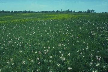
Photo by Thomas A. Meyer/DNR
Chiwaukee Prairie is situated on a gently undulating ridge and swale topography created when the level of glacial Lake Michigan was lowered in stages. It is one of the largest prairie complexes in the state and the most intact coastal wetland in southeastern Wisconsin. The prairie contains an exceptional diversity of plants and animals -- more than 400 species of vascular plants have been found here. The natural area features a mosaic of plant communities, ranging from southern sedge meadow, wet prairie, and wet-mesic prairie in the low areas, to dry-mesic prairie on the slightly elevated sandy ridges. Portions of the site are classified as calcareous fen, inhabited by calcium-loving plants. Oak opening dominated by bur and black oaks occupies higher, drier ground along the southern and western parts of the preserve. The northernmost portion, Kenosha Dunes, contains open and stabilized sand dunes. This variety of habitats, coupled with their location in the extreme southeastern corner of the state, allows several rare and geographically restricted plants, birds, invertebrates, and mammals to thrive here. Twenty-six rare plant species, 10 of which are listed as endangered or threatened grow in the prairie. More than 75 species of grassland and wetland birds have been observed during the breeding season. The Chiwaukee area was originally subdivided into hundreds of small residential lots many years ago, making the land acquisition a challenge. It was a cooperative project of The Nature Conservancy (TNC), UW-Parkside, and the DNR for many years. In 2015, TNC donated its land holdings to the DNR and established an endowment for management purposes. Chiwaukee Prairie is recognized as a National Natural Landmark by the National Park Service and was designated a State Natural Area in 1967.
Very few State Natural Areas have public facilities, but nearly all are open for a variety of recreational activities as indicated below. Generally, there are no picnic areas, restrooms, or other developments. Parking lots or designated parking areas are noted on individual SNA pages and maps. If a developed trail is present, it will normally be noted on the SNA map and/or under the Maps tab. A compass and topographic map or a GPS unit are useful tools for exploring larger, isolated SNAs.
The good majority of SNAs are isolated and have few or no facilities. Some SNAs have vehicle access lanes or parking lots, but their accessibility may vary depending on weather conditions. Parking lots and lanes are not plowed during winter. Hiking trails may be nonexistent or consist of undeveloped footpaths. A GPS unit or compass and a detailed topographic map are useful tools for exploring larger SNAs.
Entrance fees: Excepting Parfrey's Glen, the Cambrian Outlook in the Dells of the Wisconsin River, SNAs within State Parks and some within State Forests, all other DNR-owned SNAs do not have any admission fees. For more information, see Wis. Admin. Code NR 45 [exit DNR]. For non-DNR-owned SNAs, we are unaware of any vehicle or admission fees. However, please contact the landowner for more information.
Hunting Opportunities
Please be aware Chiwaukee Prairie State Natural Area is made up of several scattered properties varying in size, and habitat types and contains many residences and public roadways.
The map areas in green (see Maps tab) are larger parcels and offer the best hunting opportunities. The general public uses these areas and other nearby public lands for many recreational activities. Make sure you know where these other recreational opportunities are located for safety and to avoid user conflicts.
The map areas in black (see Maps tab) are small parcels (usually less than 2 acres) that have limited hunting opportunities based on parcel size and state laws restricting the discharge of firearms such as distance from roads and residences.
Hunters should always follow the 4 Rules of Firearm Safety (TABK):
- Treat every firearm as if loaded.
- Always point the muzzle in a safe direction.
- Be certain of your target and what's beyond it.
- Keep your finger outside the trigger guard until safe to shoot.
Allowable activities: DNR-owned land
The activities listed below are generally allowed on all DNR-owned SNA lands. Exceptions to this list of public uses, such as SNAs closed to hunting, are noted above and posted with signs on the property site.
- Hiking
- Fishing
- Cross country skiing
- Hunting
- Trapping
- Scientific research (permit required [PDF])
- Outdoor education
- Wild edibles (What is this?)
- Pets (Rules)
- Wildlife viewing
Prohibited activities: all SNAs
Although a handful of sites allow activities like primitive camping (e.g. Lower Chippewa River on sand bars) or horseback riding (e.g. S. Kettle Moraine), the activities listed below are generally prohibited on DNR-owned SNAs.
- Camping and campfires
- Collecting of animals (other than legally harvested species), non-edible fungi, rocks, minerals, fossils, archaeological artifacts, soil, downed wood, or any other natural material, alive or dead.
- Collecting for scientific research requires a permit issued by the DNR
- Collecting of plants including seeds, roots or other non-edible parts of herbaceous plants such as wildflowers or grasses
- Drones: Flying-related activities, including the use of drones, hang-gliders and model airplanes, are prohibited. Permission may be issued by the SNA Program for the use of drones for educational or research purposes
- Geocaching
- Horseback riding
- Rock climbing
- Vehicles, including bicycles, ATVs, aircraft, and snowmobiles except on trails and roadways designated for their use.
For rules governing state-owned SNAs and other state lands, please consult Chapter NR 45 Wis. Admin. Code [exit DNR].
Location
Kenosha County. 491 acres.
Driving directions
The natural area consists of two parts, separated by 116th Street. The southern portion is a large, contiguous prairie area; the northern part consists of prairie fragmented by roads and scattered homes. Southern access: from the junction of State Highways 165 and 32 south of Kenosha, go south on 32 for 1 mile, then east on 116th Street for 0.7 miles, then south on 1st Court for 0.3 miles, then west on 121st Street for 1 block, then north on 2nd Avenue to 119th Street and a parking lot. The northern portion is reached via the network of roads between 116th Street and 85th Street. The Kenosha Dunes unit is located north of 85th Street.
The DNR's state natural areas program is comprised of lands owned by the state, private conservation organizations, municipalities, other governmental agencies, educational institutions and private individuals. While the majority of SNAs are open to the public, access may vary according to individual ownership policies. Public use restrictions may apply due to public safety, or to protect endangered or threatened species or unique natural features. Lands may be temporarily closed due to specific management activities.
Users are encouraged to contact the landowner for more specific details. The data shown on these maps have been obtained from various sources, and are of varying age, reliability, and resolution. The data may contain errors or omissions and should not be interpreted as a legal representation of legal ownership boundaries. To create your custom map where you can zoom to a specific location, please use the DNR's Mapping Application.
Chiwaukee Prairie is owned by: Wisconsin DNR